
If you share the belief that South Dakota is largely flat farmland with harsh winters and few inhabitants, you’re not entirely wrong. South Dakota is one of the most sparsely populated states and agriculture is its top industry. Sure, winters can be unpleasant but the reward is long summer days with wide-open vistas, fields of vibrant sunflowers and spectacular sunsets. South Dakota has a rich Native American history, and the state is bisected by the Missouri River which also forms a chunk of its southeastern border with Nebraska. All kinds of recreational opportunities lie along the river. And when you reach the state’s southwestern corner, the desert-like Badlands and forested slopes of the Black Hills are sure to impress. Follow South Dakota’s byways to uncover the state’s scenic surprises.
- Mount Rushmore: Peter Norbeck Scenic Byway – National Scenic Byway
- Black Hills: Spearfish Canyon Scenic Byway
- Badlands Loop
- Native American Scenic Byway – National Scenic Byway
Mount Rushmore: Peter Norbeck Scenic Byway – National Scenic Byway – 120 miles
I’ve always found visiting Mount Rushmore and the Black Hills to be confusing. For starters, the area is chock full of outstanding things to see but there are also a lot of very windy roads that seem to go in all directions and the terrain changes quickly. So, it’s easy to lose your sense of place. There are several designated scenic roads in this part of South Dakota but it’s easier to just divide a road trip into two parts. The itinerary following this one, Black Hills: Spearfish Canyon Scenic Byway, focuses on the western section, largely following US 385. This route looks at Mount Rushmore and the area southwest of Rapid City. In addition to the iconic monument, it also includes a national park, state park and excellent potential for wildlife sightings.
Starting in Rapid City, the largest town in the Black Hills, follow US 16 southwest. On the way to Mount Rushmore, you’ll pass three other noteworthy attractions. From Rapid City, it’s seven miles to Reptile Gardens, one of the world’s largest reptile zoos which also has a botanical garden with more than 40,000 flowering plants. Two miles farther is Bear Country USA, said to have the world’s biggest collection of privately-owned black bears. Along the three-mile drive through the park you’ll see bobcats, cougars, elk, reindeer, mountain goats, bighorn sheep, pronghorn and bison. From Bear Country USA, follow the Mount Rushmore signs on US 16 and US 16A another 12 miles to Rushmore Tramway Adventures, featuring ziplines, an alpine slide, downhill tubing and rope climbing.
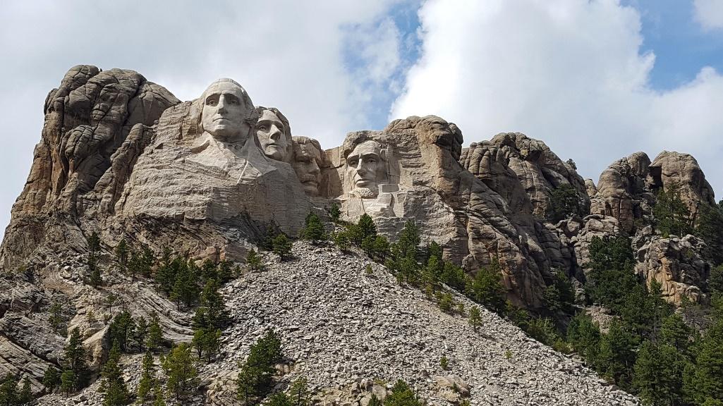
From here, it’s two more miles to the region’s star attraction, Mount Rushmore. Starting in 1927, it took Gutzon Borglum 14 years to sculpt the 60-foot granite heads of George Washington, Thomas Jefferson, Theodore Roosevelt and Abraham Lincoln. There’s a fee to park but the monument itself is free to enter. The Evening Lighting Ceremony takes place every night from late May through the end of September.
It’s worth noting that the most compelling approach to Mount Rushmore is US 16A, driving south to north. So, instead of following US 16A south to Rushmore Tramway Adventures, take Reed Street/SD 40 east to Playhouse Road south. Go about four miles on Playhouse Road and then take a right onto US 16A north. From this intersection, it’s about 11 miles to Mount Rushmore. Called Iron Mountain Road, it’s dramatically curvy with narrow tunnels so look at this map to determine whether it’s a fit for your RV.
Mount Rushmore is on South Dakota Highway 244. You’re now also driving the Peter Norbeck Scenic Byway, a double loop through some of the Black Hills’ most impressive scenery. Norbeck was a South Dakota governor and senator who gets much of the credit for developing tourism here, which today attracts some 3.6 million visitors annually to the area’s national parks.
As SD 244 descends west from Mount Rushmore, a profile view of George Washington will appear to the right, less than a mile from the parking lot. Then, start looking for Black Elk Peak to the left. At 7,242 feet, it’s the highest mountain between the Rocky Mountains and France. You can hike to the top where there’s a decommissioned stone fire tower built by the Civilian Conservation Corps in 1938.
The byway continues twisting west through forest and stone walls with various trailheads, lakes and camping areas. In about nine miles, SD 244 intersects US 385 which is also a main route in our Black Hills article below. But for this itinerary, take a left onto US 385 and then another quick left onto SD 87. Named after the imposing granite spires it passes, the Needles Highway was completed in 1922 and includes 14 miles of sharp turns and narrow tunnels. It travels through Custer State Park and again, you’ll want to check the map to see if your RV can squeeze through.
Custer State Park is South Dakota’s first and largest state park with numerous activities including hiking, biking, birdwatching, boating, fishing and horseback riding. It’s even home to a regional theater that started in 1946, the Black Hills Playhouse. The Peter Norbeck Outdoor Education Center has displays and programs on local history and nature. Aside from being gorgeous, the park’s other main attribute is its animals. In 1914, 36 bison were purchased followed in later years by pronghorn and Rocky Mountain bighorn sheep. Today, nearly 1,400 bison roam freely as one of the largest publicly owned bison herds in the world. The Wildlife Loop Road runs 18 miles over hills, across prairies and through red-walled canyons. It’s designed to showcase the park’s animals, and in addition to those mentioned earlier, you might also spot deer, elk, burrowing owls, coyotes, mountain lions, prairie dogs and a group of the park’s feral burros. The Bison Center features interpretive displays along with reminders to keep your distance from the animals.
To the west, Wildlife Loop Road intersects SD 87 near Custer State Park’s Blue Bell Entrance. From here, continue south 13.5 miles to Wind Cave National Park. Established in 1903, it protects Earth’s seventh longest known cave. With a length of nearly 162 miles, Wind Cave ranks third in the U.S. after neighboring Jewel Cave and Kentucky’s Mammoth, the world’s longest cave. Ranger-guided tours are the only way to explore Wind Cave and you must purchase a ticket. Reservations are highly recommended, particularly in summer. Above ground there are hiking trails, a picnic area and campground. If you’re curious about Jewel Cave, check out the Black Hills article below.
Finally, from Wind Cave continue another 12 miles south on US 385 to Hot Springs, named for its natural mineral pools. The town is also home to the Mammoth Site, a museum and active dig with yet another “world’s biggest” designation. In this case, it’s the planet’s largest mammoth research facility where more than 60 mammoths and some 87 other Late Ice Age animals have been excavated. After all this, it’s only an hour back to Rapid City following US 18 and SD 79. Obviously, it will take more than one day to experience these activities!
Black Hills: Spearfish Canyon Scenic Byway – 125 miles
The Black Hills are an alpine oasis surrounded by the Great Plains. There’s nothing like them in the Midwest. Formed by volcanic activity some 1.6 billion years ago, the Black Hills rise impressively to heights of 7,242 feet. In fact, Black Elk Peak is the highest mountain between the Rockies and Pyrenees in France. Located mostly in southwestern South Dakota, the Black Hills are about 110 miles long and 70 miles wide, encompassing an area larger than Massachusetts. Covered by forests with numerous waterfalls and lakes, the Black Hills are also known for their granite formations, particularly the one sculpted by Gutzon Borglum showcasing the four presidents. While Mount Rushmore and the scenic roads southwest of Rapid City are the focus of the article above, this story breaks down the sites farther west that run through the heart of the Black Hills.
Starting about 55 miles southwest of Rapid City, guided tours explore Jewel Cave National Monument, the world’s fifth longest known cave. More than 215 miles have been mapped and surveyed and in the U.S., only Mammoth Cave in Kentucky is bigger; in fact, it’s the world’s largest cave. That said, South Dakota also has nearby Wind Cave which ranks third in the U.S. and seventh in the world. At Jewel Cave, you’ll need a ticket to tour and be sure to make reservations, particularly in the summer. The park also offers hiking trails and picnicking but no camping.
From Jewel Cave, take US 16 east to Custer. In 1874, gold was discovered nearby, launching the Black Hills mining boom. Today, the small town has campgrounds, restaurants and a brewery. Then, heading north on US 385 it’s seven miles to Crazy Horse Memorial. While the better-known Mount Rushmore is 17 miles away, Crazy Horse is the “world’s largest mountain carving in progress.” The vision of sculptor Korczak Ziolkowski, it’s been under construction since 1948 and isn’t close to being finished. Even so, the profile of Oglala Lakota leader, Crazy Horse can be seen clearly and the memorial also features three museums, an orientation film and views of the colossal granite sculpture from a veranda.
From Crazy Horse, go 12 miles north on US 385 to Hill City where you can board the Black Hills Central Railroad for a 20-mile steam-powered ride to Keystone and back. The “1880 Train” operates mid-May through mid-October with a Holiday Express from Thanksgiving to Christmas.
For the next 42 miles on its way to Deadwood, US 385 rolls north through forest, passing wineries, cabins, motels, campgrounds and two of the most picturesque lakes in the Black Hills. From Hill City, it’s 5.5 miles to 375-acre Sheridan Lake, featuring the largest campground in Black Hills National Forest. There’s a boat launch, swimming beach, picnic area and trailheads. Trout, northern pike, perch and bass are fished in the waters. Ten miles farther north on US 385 is 800-acre Pactola Reservoir, offering most of the same amenities as Sheridan Lake. Both complexes are very popular so keep that in mind as you plan.
From Pactola it’s 28 miles north to Deadwood, perhaps the most famous town in South Dakota. While gold was first discovered further south in Custer, Deadwood is where the rush really took off. So much so that in 1877 the U.S. government seized the Black Hills from the Sioux, violating an 1868 treaty. Booms, busts and fires have given this town a colorful history, along with legends such as Wild Bill Hickok and Calamity Jane. HBO had a popular TV series set in Deadwood. The Old West theme lives on in the restored downtown. In 1989 limited-wage gambling was legalized and today, there are casinos along with resort hotels, restaurants and galleries. A mile out of town is the Broken Boot Gold Mine which gives 30-minute tours every 30 minutes from Memorial Day through Labor Day.
Deadwood sits in a gulch and as you head three miles west to Lead (pronounced “leed”), the highway climbs steeply to this little town perched on a hill. Mining was also once the backbone of Lead’s economy, and until its closing in 2002, the Homestake Gold Mine was the deepest and most productive gold mine in the Western Hemisphere. Today, it operates as an underground scientific research facility. Up top, the fee-free Sanford Lab Homestake Visitor Center has exhibits and an observation deck for viewing the massive opencut. The nearby Black Hills Mining Museum displays relics and memorabilia as well as a life-size mine replica.
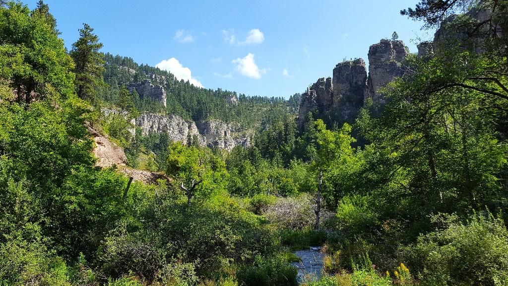
From Lead, go west on US 14A to Spearfish. This 28-mile route follows the Spearfish Canyon Scenic Byway, one of the prettiest roads in the Black Hills, not to mention all of South Dakota. The highway heads south before curving north around 7,064-foot Terry Peak, with seasonal skiing at the highest resort between the Rocky Mountains and French Alps. 13 miles from Lead the byway reaches Spearfish Canyon Nature Area with several hiking trails, waterfalls and campgrounds. Spearfish Canyon is characterized by thick vegetation and 1,000-foot walls, carved by Spearfish Creek. Fishing, birding, rock climbing, wildlife viewing, picnicking and fall leaf peeping are prime activities.
US 14A eventually winds into Spearfish. Incorporated in 1888, the town and region’s history is told through exhibits at the High Plains Western Heritage Center. The 49-acre museum focuses on topics including Native Americans, pioneering, cattle and sheep ranching, rodeo, transportation and mining. Outdoors you can explore a furnished one-room schoolhouse, homestead log cabin and antique farm and ranch equipment. The D.C. Booth National Historic Fish Hatchery is one of America’s oldest operating hatcheries with trout viewing, a museum, replica fish-transporting railcar and nature trails. Downtown offers antiques, outdoor sporting goods, coffee shops, wine bars and the restored Matthews Opera House and Art Gallery.
The byway ends in Spearfish but the journey continues 18 miles west and into Wyoming on I-90. The Vore Buffalo Jump is an important archaeological site where Late-Prehistoric Plains Indians herded bison and drove them over a cliff. Below, tribe members waited to finish the kills and butcher the animals. Today, excavation continues which offers guided tours from June through Labor Day.
From Spearfish heading southeast on I-90, it’s 20 miles to Sturgis, site of the huge annual ten-day motorcycle rally. Another 28 miles and you’re in Rapid City, the state’s attractive second largest city and popular summertime destination with campgrounds, restaurants and RV repair.
Badlands Loop – 205 miles
This road trip starts and ends in Rapid City. The actual Badlands Loop Scenic Byway only includes Badlands National Park but if you’re staying in the Rapid City area, it’s worth driving to the park via the southern route and then returning to Rapid City on the freeway. Start by heading east out of the city on South Dakota Highway 44. The southwestern part of the state boasts incredibly dynamic and diverse landscapes, and as you leave the forested foothills, the land changes to prairie. Some 30 miles from Rapid City, look to the north for the Creston Dinosaur, thought to be the first roadside dinosaur attraction in North America. Built in 1933 and then rehabbed in 1998, the dinosaur isn’t in great shape but still photo worthy.
Soon, SD 44 enters Buffalo Gap National Grassland. Though undeveloped, you can camp and look for bison, pronghorn, deer, prairie dogs, jackrabbits and a lot of birds. You’ll begin to see the jagged ridges of Badlands National Park appear across the prairie. The highway runs just north of the Pine Ridge Reservation, home to the Oglala Sioux Tribe. For something unique, tune into KILI 90.1 FM, the “Voice of the Lakota Nation,” which broadcasts many programs in the Lakota language.
About 73 miles from Rapid City, SD 44 arrives at Interior where you’ll then follow SD 377 northeast another two miles to Badlands National Park. Just passed the entrance, Cedar Pass Lodge has a campground, cabins and gift shop that sells Northern Plains Native artwork and crafts as well as regional and handmade gifts. The restaurant’s specialty is Famous Indian Tacos made with fresh fry bread.
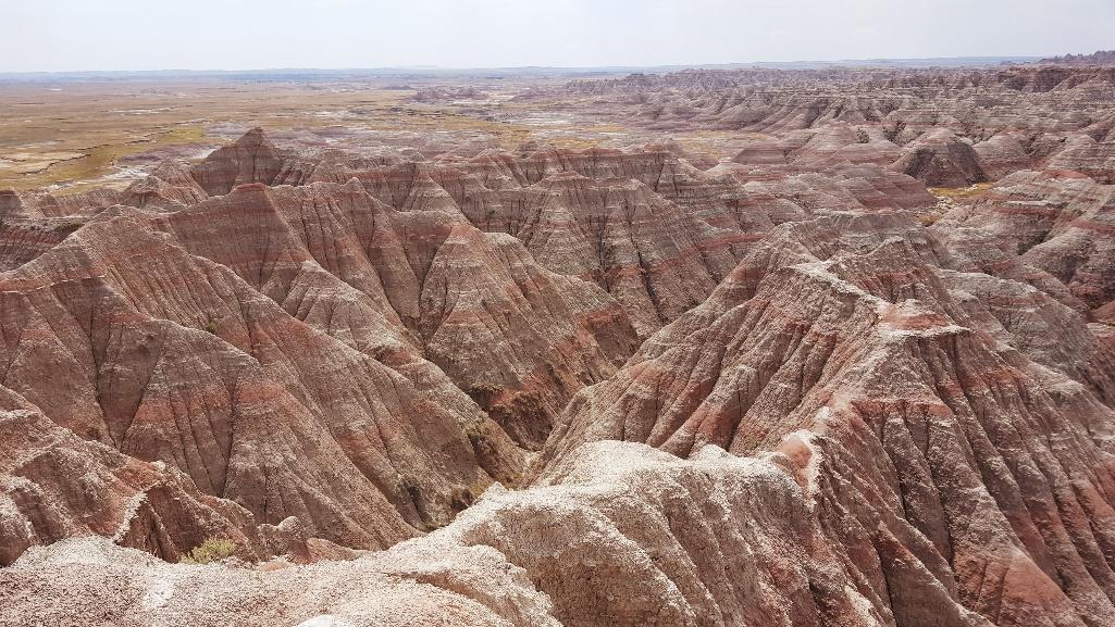
Badlands National Park is a weirdly beautiful, out-of-place setting with colorful hills, buttes and ravines. Native Americans were first to call it “mako sica” or “bad lands.” There are few trees or bushes. Instead grasses change shades from green to gold as seasons pass. It’s a geological playground, fashioned over millions of years. Sand, silt and clay were deposited in layers, forming sedimentary rocks. Then, erosion took over. For the last 500,000 years water and wind have transformed the flat floodplain and the process continues. One day, the Badlands will completely wear away, but since this erosion occurs at about one inch per year, it will take another 500,000 years.
Just beyond Cedar Pass Lodge is the Ben Reifel Visitor Center with exhibits, a bookstore and the Fossil Preparation Lab. This busy area is where the Badlands Loop Scenic Byway starts. Also designated SD 240, follow the highway another five miles north to the park’s Northeast Entrance and then turn around, returning to the visitor center. Then, continue on SD 240 as it moves deeper into the park. (You can also continue to the Minuteman Missile National Historic Site and turn around there, as described in the paragraph below.)
From the Northeast Entrance it’s 27 miles to the Pinnacles Entrance on the western side. Along the route are 16 designated scenic overlooks and numerous hiking trails, including the Fossil Exhibit Trail. The Badlands are home to one of the world’s richest fossil beds, evidence that the saber-toothed cat, rhino and horse were ancient mammals once living here.
About ½ mile before exiting the park on the western side via the Pinnacles Entrance, look for the gravel Sage Creek Rim Road to the left. It leads to the park’s other campground, Sage Creek, which is first-come, first-served with 22 sites. Along the way are several other viewpoints as well as the Roberts Prairie Dog Town, home of the park’s largest colony. Bison are best seen from Sage Creek Rim Road, too. Bighorn sheep are often spotted on rocky precipices at overlooks and if you’re really lucky, you might see a black-footed ferret at dusk or dawn. Once declared extinct, the species now thrives in Badlands National Park.
From Pinnacles Entrance, it’s eight miles north to Wall and the National Grasslands Visitor Center with exhibits and information on Buffalo Gap and several other restored prairies managed by the National Forest Service. Nearby, from a humble start in 1931 to today’s major tourist draw, Wall Drug sells everything from western wear, moccasins and jewelry to camping supplies and campy souvenirs. Or just snap a photo of the family with the six-foot rabbit, giant jackalope, buckin’ bronc or mini-Mount Rushmore.
A more sobering attraction lies east of Wall. In fact, if you drive 21 miles on I-90 to the Minuteman Missile National Historic Site, you’ve just about come full circle on the Badlands Loop Scenic Byway as the Northeast Entrance is now just four miles south. The missile site is a Cold War relic where two of 15 original Launch Control Facilities are preserved. From 1963 through the early 1990s crews maintained and controlled 150 silos holding Minuteman Intercontinental Ballistic Missiles. The adjacent visitor center has displays on nuclear deterrence and the Cold War. From the missile site, it’s about an hour west to Rapid City on I-90.
Native American Scenic Byway – National Scenic Byway – 390 miles

Beginning in southcentral South Dakota, this byway follows the course of the Missouri River north, crossing into North Dakota and traveling through the lands of the Crow Creek, Lower Brule, Cheyenne River and Standing Rock Sioux. As you drive the rural roads, keep a lookout for bison herds and massive sunflower fields, which bloom early to mid-August through early September.
The road trip starts in dramatic fashion: on a bluff overlooking the Missouri River and looking up at Dignity of Earth and Sky, a stunning 50-foot stainless steel sculpture. Wearing native dress and moccasins, a woman holds a star quilt made of diamond shapes in shades of the blue water and sky surrounding her. In the words of Dale Lamphere, South Dakota Artist Laureate, “Dignity represents the courage, perseverance and wisdom of the Lakota and Dakota culture in South Dakota.” Completed in 2016, Lamphere’s sculpture lies between exits 263 and 265 on I-90 and can only be reached from the freeway. Dignity is in Chamberlain, a small town 140 miles west of Sioux Falls and 210 miles east of Rapid City, South Dakota’s two largest metropolises.
Chamberlain is also home to the Aktá Lakota Museum & Cultural Center, located four miles north of Dignity. Meaning “to honor the people,” Aktá Lakota concentrates specifically on Northern Plains tribes, making it unique from other American Indian museums and cultural centers. Most of the collection covers the “early reservation period” from 1800 to 1930 and includes artifacts made from beads, hides, quills and feathers.
The byway then heads north on South Dakota Highway 50 to Fort Thompson, 21 miles away. The route parallels the Missouri, the USA’s longest river. From its headwaters in Montana, the Missouri flows more than 2,300 miles before emptying into the Mississippi River north of St. Louis. The Missouri is particularly impressive in South Dakota where it splits the state in half before forming a section of the border between South Dakota and Nebraska. It’s also very wide in places with many wildlife reserves along the riverbanks. Following BIA Highway 4 into Fort Thompson, look for the Fort Thompson Mounds, about 18 miles from Chamberlain. The mounds are an ancient burial site and National Historic Landmark. You’re on the Crow Creek Sioux Reservation and Fort Thompson is four miles farther with fuel, a casino and north of town, a bison herd that’s often grazing. At Big Bend Dam and Lake Sharpe, the Spirit of the Circle Monument honors 1,300 people who died in the 1860s from malnutrition and exposure. The lake has camping, boating, picnicking and fishing. Hunting is also popular in the area.
At Big Bend Dam, the byway crosses the Missouri and moves northwest through the land of the Lower Brule Sioux. Road numbers change, but generally you’ll follow SD 1806 alongside the river to Pierre, about 75 miles from Fort Thompson. With 14,000 residents, Pierre is the second smallest state capital. You can tour the capitol building and South Dakota Cultural Heritage Center. Although it’s currently closed for renovation, the center has rotating exhibits on many themes, including the state’s complicated Native American history. Across the river in Fort Pierre, the Casey Tibbs South Dakota Rodeo Center celebrates South Dakota’s rich rodeo tradition with memorabilia of nine-time World Champion Casey Tibbs, trick rider Mattie Goff Newcombe and other state legends. The museum features a horse wagon and western art. And if you want to camp where the Lewis and Clark Expedition first met the Lakota people in 1804, head to Fischers Lilly Park. Near the campground there’s a marker noting the important event, called the Bad River Encounter Site because it almost led to an armed confrontation.
From Pierre, it’s about eight miles north to Oahe Dam. With 2,250 miles of shoreline, Lake Oahe engulfs the Missouri River which feeds it. The lake is the biggest body of water in South Dakota and the fourth largest reservoir in the U.S. It runs 231 miles between two state capitals, Pierre and Bismarck, North Dakota. The lake has 51 recreation areas spread along its shores with camping, picnicking, fishing, boating, waterskiing, swimming, hiking, biking and hunting. The birds, wildlife and waterscapes are loved by photographers. The Oahe Dam has a visitor center that’s open year-round on weekdays with a daily dam tour from Memorial Day through Labor Day.
From Oahe Dam, the byway heads northwest about 80 miles through the Cheyenne River Lakota Nation, crossing an arm of Lake Oahe before reaching Eagle Butte. Since 2015, the town has become known for its murals. In summer it hosts RedCan, a graffiti jam where community members create artwork incorporating Lakota stories and words. The HVJ Cultural Center and Gift Shop sells Native American arts and crafts. There’s also a hall of murals featuring work by local artists.
Pressing onward, the road trip continues 80 miles northeast to Mobridge, a larger town with fast food, grocery and hardware stores. Mobridge lies on the banks of Lake Oahe and the Missouri River, just outside the land of the Standing Rock Sioux Tribe. Go inside the 1930s Scherr-Howe Event Center, aka the Mobridge City Auditorium, to see more murals. These ten were created in 1942 by renowned Native American artist Oscar Howe. Close by, the Klein Museum preserves local heritage and includes many Native American artifacts. It also focuses on the life of Sitting Bull, a Hunkpapa Teton Sioux chief who united Sioux tribes against white settlers taking tribal land in the mid-1800s.
Across from Mobridge on a bluff overlooking the Missouri River is Sitting Bull Monument, a granite bust marking what is said to be the Sioux leader’s grave. There’s also a monument to Sacagawea, a Native American and only woman on the 1804 Lewis and Clark Expedition. From Mobridge, the byway leaves South Dakota but continues north through the Standing Rock Indian Reservation. It’s 50 miles to Fort Yates, North Dakota. Established in 1874 as a military post, today the Fort Yates Stockade is the only remaining original building. Stop by the Sitting Bull Visitor Center for information on attractions, events and tours. It’s located on the campus of Sitting Bull College where the bookstore has Native American crafts, jewelry, star quilts and beadwork. Nearby, the Sitting Bull Burial Site is where the Sioux chief was originally laid to rest in 1890 before his remains were allegedly moved to Mobridge in 1953. Lastly, the Standing Rock Monument is a boulder that legend says is the petrified form of a woman and her child. This symbolic stone inspired the name for Standing Rock Sioux Reservation. From Fort Yates, the byway continues north through prairie another 26 miles before ending where the Cannonball River flows into the Missouri. It’s another 42 miles north to Bismarck.
