On your first road trip to Arkansas, you quickly understand why it’s nicknamed The Natural State. Arkansas has some of the prettiest landscapes in the U.S., particularly in the northwest quadrant where the thick forests, rocky bluffs and rolling hills of the Ozark Mountains dominate. But the eastern side is pretty amazing, too, as the Mississippi River continues its slow roll from Minnesota to the Gulf of Mexico past agricultural fields and swampland. A national park dedicated to historic hot springs, country cooking, small family farms and craft shops means there’s a lot of fascinating culture in The Natural State, too. Arkansas has several scenic byways and the ones we’ve chosen provide an overview of the topography and heritage of this captivating state.
- Arkansas Scenic 7 Byway
- Boston Mountains Scenic Loop
- Pig Trail Scenic Byway
- Ozark Highlands Scenic Byway
- Great River Road – All-American Road
Arkansas Scenic 7 Byway – 249 miles, from Harrison south to DeGray Lake Resort State Park, including side trips
This diverse byway is probably the state’s finest because it exemplifies Arkansas’s “Natural State” nickname: mountains, forests and lakes plus several memorable historic towns. The byway also passes near several state parks and one national park, meaning there are ample camping and outdoor recreational opportunities. The byway essentially runs the length of the state, from north to south, crossing two mountain ranges and the Arkansas River Valley before cutting through pine woodlands on its way to Louisiana.
If you don’t have time to drive the entire length, concentrate on the northern half, starting in Harrison, about 20 miles south of the Missouri state line. With RV parks, big box stores and a brewery, Harrison makes a good basecamp. The downtown square is a National Historic District where flower baskets hang from old brick storefronts. There are art galleries, antique stores and the 1929 Lyric Theater. Once the area’s first movie theater for “talkies,” it’s now a much-loved venue for plays and concerts. And if you’re needing an upgrade from camping, consider a stay at the beautifully restored 1929 Hotel Seville. Nearby, the Boone County Heritage Museum has exhibits on the Ozarks, early Harrison settlers, the Civil War and the town’s railroad past. And in a region renowned for its mountains, the 71-acre Baker Prairie is all that remains of a 5,000 acre prairie ecosystem. Located next to Harrison High School, the nature reserve is home to more than 250 different species of animals and plants, including several rare ones.
From Harrison, follow State Highway 7 south toward Jasper. In about 13 miles the road crosses the Buffalo River, America’s first National River, known for its impressive limestone and sandstone walls. Established in 1972 and administered by the National Park Service, the Buffalo is one of the last undammed rivers in the continental U.S., flowing freely for 135 miles. Highway 7 intersects the river and only runs through a small section of national river land, but the highway connects with other roads that give access to kayaking, hiking and swimming. The Buffalo River is also prime fishing, home to 74 species. About 15 miles from Harrison, a right turn leads to Ozark Campground, a short drive north.
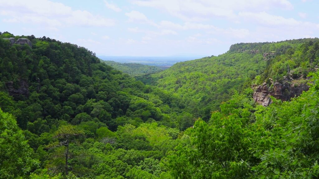
Another four miles south and Highway 7 enters Jasper, a small town focused on tourism with outdoor outfitters, craft shops and restaurants, including the Ozark Cafe. It originally opened in 1909 and serves burgers, milkshakes and breakfast. From Jasper, Highway 7 continues six miles south to another famous restaurant, the Cliff House Inn. Serving homecooked meals and fresh baked pies and cobblers, the dining room overlooks the Arkansas Grand Canyon, the state’s deepest valley. The inn also has five guestrooms.
Highway 7 then twists and turns deeper into Ozark National Forest. About eight miles from Cliff House Inn, take a short 4.5 mile detour on Highway 16 and Newton County Road 28 to the Alum Cove Natural Bridge Geological Area. A short hike leads to a 130-foot-long stone arch, all that remains of a quartz sandstone cave eroded over time.
Back on Highway 7, the crooked and steep road continues south through forest made largely of oak and hickory. About a mile before Pelsor, look for the Fairview Trailhead, an access point for the Ozark Highlands Trail, offering 270 miles of year-round hiking and backpacking through some of the region’s most rugged terrain. In Pelsor, a fun stop is the Sand Gap General Store where you’ll find everything from souvenirs, spices and sourdough bread to Cinnamon Sugar Pork Rinds. The general store has been in business for more than 100 years.
More mountain beauty and scenic overlooks unfold as Highway 7 continues another 29 miles south to Dover where two lanes swell to four. The scenic byway then enters Russellville where it intersects I-40. This busy area has fast food, fuel, grocery stores and pharmacies. But despite the development, this is also where you’ll encounter several outstanding state parks. Russellville lies near Lake Dardanelle, a large reservoir on the Arkansas River. Lake Dardanelle State Park has two locations, essentially across the river from each other. The main site on the Russellville side has camping, swimming, fishing, hiking, lake tours and a visitor center with five aquariums. The state park is also a Trail of Tears National Historic Site and features exhibits on the U.S. government’s forced removal of the Cherokee, Chickasaw, Choctaw, Muscogee and Seminole people. Between late 1831 and 1859, groups of these Native Americans passed through this area as they were pushed off their ancestral homelands in the east to newly designated territory west of the Mississippi River.
Just south of Russellville is the historic river port town of Dardanelle where you can see the imposing Lake Dardanelle Dam. Just up Highway 22 is the other part of Lake Dardanelle State Park with more camping and outdoor activities. Another state park worth checking out lies seven miles west of the town of Dardanelle on Highway 155. A steep drive leads to the top of 1,350-foot Mount Nebo. In addition to spectacular views of the Arkansas River Valley and more than 30 miles of hiking and mountain biking trails, Mount Nebo State Park features rustic-style cabins, pavilions and bridges, many constructed by the 1930s-era Civilian Conservation Corps.
Back in Dardanelle, take Highway 7 south eight miles Centerville. Then, take a left onto Highway 254 and go east 16 miles to the area’s third excellent state park: Petit Jean. It’s also Arkansas’s first state park and, like Mt. Nebo, features native log and stone facilities built by the Civilian Conservation Corps. The CCC also constructed Mather Lodge, a 24-room hotel overlooking Cedar Creek Canyon with a restaurant and gift shop. The park has cabins and campsites, too. Hiking, swimming, fishing, kayaking and pedal boating are popular. And hikes lead to some of Petit Jean’s impressive overlooks and natural attractions including 95-foot Cedar Falls, Seven Hollows, Bear Cave, the Grotto and Natural Bridge.
Heading back to Highway 7, you’ll pass the southern boundary of Holla Bend National Wildlife Refuge where a self-guided auto tour leads to various habitats, hiking trails and an observation tower.
Then, back in Centerville, follow Highway 7 south through farmland and woodlands to Ola and onto Nimrod Lake, another large reservoir with camping and outdoor recreation. The Nimrod Dam is worth a look, too. From Centerville, it’s 15 miles to the dam and then Highway 7 curves into Ouachita National Forest, home to another of Arkansas’s significant ranges, the Ouachita Mountains. About 19 miles from the dam, the Winona Scenic Drive takes off from Highway 7 and runs 27 miles east to Highway 9. The road is maintained gravel and passes through some of Arkansas’s most impressive high country scenery.
From the Winona Scenic Drive turnoff, it’s another 10 miles to Highway 192. Turn right and go 8.5 miles to Lake Ouachita State Park. This reservoir is Arkansas’s largest lake, with 40,000 acres of water enclosed by Ouachita National Forest. Swimming, waterskiing, scuba diving, boating, kayaking, fishing and hiking are popular, and the park has campsites and cabins.
Back on Highway 7, it’s another 15.5 miles to Hot Springs, one of Arkansas’s top destinations. This hip and fun city is surrounded by Hot Springs National Park. But while the park has many wilderness trails to explore, don’t expect outdoor pools of bubbling geothermal water. Instead, the hot springs are found inside ornate buildings along the Grand Promenade. Today, Bathhouse Row consists of eight structures built between 1892 and 1923. While a few still offer spa services, the other buildings have been turned into the park’s visitor center, gift store and a brewery. And while there’s no outdoor soaking in the park, there are three places where you can see and touch the thermal water. The Hot Water Cascade at Arlington Lawn is the park’s largest visible spring where water gushes down a steep cliff into two pools. The Display Spring emanates from a hillside and flows into a shallow pool behind the Maurice Bathhouse. And the Fordyce Fountains are two hexagonal sculptures with shooting streams located at the park’s former “grand entrance” between the Fordyce and Maurice bathhouses. Bathhouse Row is part of Hot Springs’ charismatic downtown with shopping and cafes. During their heyday in the 1920s, 30s and 40s, the bathhouses attracted gambling, bootlegging and other “extreme pleasures” as explored in the Gangster Museum of America. And though it’s not part of the famous Madame Tussauds’ chain, gambling and gore are also on display at the Josephine Tussaud Wax Museum where you’ll find more than 100 wax creations. South of town, highlights at the 210-acre Garvan Woodland Gardens include the Camelia Trail, Southern Inspiration Garden, a Japanese garden and an annual tulip festival.
From Hot Springs, follow Highway 7 another 27 miles south to DeGray Lake Resort State Park. This is Arkansas’s only resort state park and features a large lodge, restaurant, golf course, disc golf, hiking, mountain biking, guided horseback riding and birding tours. The lake offers all kinds of water activities including swimming, paddling, sunset cruises and snorkeling trips.
From DeGray Lake, Highway 7 meanders onto Arkadelphia and Camden where it becomes a four-lane highway as it heads toward El Dorado and the Louisiana state line.
Boston Mountains Scenic Loop – 74 miles, from Alma north to Fayetteville following US 71

Extending across northern Arkansas and southern Missouri, the Ozark Mountains are significant for their natural beauty and cultural importance. And yet, Arkansas’s scenic byways program is pretty confusing in this region, where a mishmash of roads are labeled as scenic. So starting in the west and moving east, here are three routes that run north/south and parallel to each other. By going up one, coming down another and then going back up the third, you’ll pretty much experience the best of the Arkansas Ozarks.
First, a geography lesson: the Boston Mountains make up the southwestern part of the Ozark plateau, and they are the highest and most jagged part of the Ozarks. Fort Smith lies in northwest Arkansas on the border with Oklahoma. It’s Arkansas’s second largest city and the Boston Mountains Scenic Loop connects it with the state’s second biggest city, Fayetteville. Following I-49, it’s an hour’s drive north from Fort Smith to Fayetteville. The interstate forms the byway’s western part and yes, freeways can be designated as scenic byways. For a longer, more intimate journey to Fayetteville, take US 71. It’s the eastern section of the loop, running parallel to I-49 for 47 miles.
Fifteen miles east of Fort Smith, US 71 heads north of I-40 at Alma. A former stagecoach route, US 71 curves through the mountainous terrain about 20 miles to Lake Fort Smith State Park. Offering camping, kayaking, hiking, mountain biking and fishing, the park is also the western end of the 270-mile Ozark Highlands Trail, popular with backpackers as noted in our Arkansas Scenic 7 Byway itinerary above. Back on US 71 and five minutes from Lake Fort Smith State Park, stop by Artist Point Gift Shop and Cultural Center for sensational valley and mountain views plus souvenirs, local crafts and fudge. There’s also a small museum.
Another seven miles north on US 71 brings you to Winslow where a 12 mile detour west on Highway 74 leads to Devil’s Den, another excellent deep forest state park known for hiking, biking, backpacking and horseback riding. Lake Devil has fishing and boating where you can rent canoes and pedal boats. Camping and cabins are available, too. The park’s Yellow Rock Trail is one of the state’s top hikes with majestic views and intriguing rock formations. About two miles before the visitor center, there’s an unmarked parking area for Moonshiners Cave. The short trail isn’t part of the park but it’s an easy, pretty hike to a waterfall and large cave that was allegedly used by bootleggers to make moonshine.Back in Winslow, continue north on US 71 and in 18 miles you’ll reach the Arkansas Air & Military Museum where more than 2,000 original artifacts, aviation memorabilia, aircraft and military vehicles are on display. Then, it’s just four miles to Fayetteville. Home to the University of Arkansas, this energetic college town with a cool downtown square has a great restaurant and brewery scene. There’s also a year-round farmers market, plenty of nearby hiking and biking trails and the gorgeous Botanical Garden of the Ozarks.
Pig Trail Scenic Byway – 103 miles, from Eureka Springs south to I-40

This second Ozark route runs north/south and parallel to the Boston Mountains Scenic Loop east of Fayetteville. From Eureka Springs, State Highway 23 runs south where a section makes up the Pig Trail Scenic Byway as you get closer to I-40. According to the Arkansas Department of Parks, Heritage and Tourism, there are a couple of explanations for the unique name. The first is that “since this portion of AR 23 was part of a popular back road route into Fayetteville for University of Arkansas Razorback football games, it was therefore dubbed the Pig Trail. The other explanation is simply that the road is as twisty as the tail of a wild hog.” The Pig Trail is particularly notable for bikers as it was recently named America’s top motorcycle ride in a USA Today Readers’ Choice poll.
Start your road trip in the far north because a visit to northwest Arkansas would be remiss without going to Eureka Springs, near where Highway 23 starts at the Missouri state line. Located about an hour northeast of Fayetteville, tourism has always been Eureka Springs’ lifeblood. Starting in 1879, the therapeutic waters of the area’s mineral springs turned the town into a prominent health center. Eureka Springs became a successful resort destination and its popularity ebbed and flowed over the years. In 1970 the entire town was placed on the National Register of Historic Places and today, it flourishes as a funky, progressive travel spot with numerous restaurants specializing in steaks, seafood, barbecue, pizza and vegetarian cooking. There’s a whisky bar, breweries and all kinds of shopping, historic hotels, lodges and campgrounds. Numerous spas continue Eureka Springs health, wellness and relaxation tradition. The town has always attracted artists and writers and so it features many art galleries, a summer opera series called Opera in the Ozarks and in November, the Ozark Folk Festival, the longest running folk festival in America. The Great Passion Play is a major draw where the last week of Jesus Christ’s life is staged in a 4,000-seat outdoor amphitheater. Performances run a couple of nights a week from mid-May through October. Nearby, the seven-story high Christ of the Ozarks welcomes visitors with massive open arms. Made of concrete and steel, the huge figure was designed by one of Mount Rushmore’s sculptors and erected in 1966. Pivot Rock Park is another quirky roadside attraction with several peculiar geological formations, including Natural Bridge and the park’s namesake, Pivot Rock, which looks like an inverted triangle. With two rivers and three lakes nearby, outdoor activities run the gamut, and Eureka Springs also has two golf courses.
Following Highway 23 south out of Eureka Springs, it’s five miles to Quigley’s Castle. Starting in the 1940s, this house was built over time by Elise Quigley and her family. Now a tourist attraction run by her grandchildren, the odd home’s outside walls are covered with fossils, crystals, arrowheads and stones. Inside the house are family antiques, a Butterfly Wall and large tropical plants that grow in four feet of dirt left bare between the edges of the walls and the living area. There’s also a perennial garden with more than 400 varieties of flowers.
Continuing south along Highway 23, it’s four miles to Turpentine Creek Wildlife Refuge, which provides lifetime care for rescued tigers, lions, leopards, cougars and bears. The refuge offers tram rides, educational programming and lodging, including six RV spaces and two Glamping Safari Tents.
From Turpentine Creek go another four miles south on Highway 23 to Highway 127 where a right turn and another 12 miles west leads to Hobbs State Park-Conservation Area. It’s Arkansas’s largest state park and is popular for hiking, mountain biking and horseback riding. There are 11 primitive campsites, six accessible by mountain biking. Nearby but not part of the park is War Eagle Cavern where guided tours are led through the various rooms of this lakeside cave, featuring the largest natural cavern entrance in Arkansas.
Back on Highway 23 and continuing south, you’ll find a couple of RV parks and campgrounds, including about 40 campsites at Withrow Springs State Park where hiking, floating on the stream and fishing are the main activities. Highway 23 then wanders through the picturesque countryside to Huntsville, a small town with restaurants, groceries and fuel. You’re 28 miles south of Eureka Springs now.
Another 24.5 miles south brings you to Brashears and the official start of the Pig Trail Scenic Byway. In addition to the unusual name, the route is different from most byways because it’s strictly about the road. The Arkansas Department of Transportation describes the byway like this: “With its many steep inclines and sharp curves, driving the Pig Trail may be likened to riding a roller coaster. Trees crowd the roadside, creating a shady corridor during the summer in some areas and displaying stunning fall color. Very little development has occurred along this route, offering travelers a glimpse of the Ozarks that would have been familiar to the early settlers.”
Located in the Boston Mountains, the area is also part of the White Rock Wildlife Management Area where hunting, camping and picnicking are pastimes. This is waterfall country, too, although it takes work to reach most of them. As you roll up and down through deep hollows and steep benched ridges, 5.5 miles from Brashears the Pig Trail reaches the parking area for Cherry Bend Trailhead. This is an access point for the Ozark Highlands Trail, as we’ve mentioned in the Boston Mountains Scenic Loop and Arkansas Scenic 7 Byway itineraries, above. Though not on the actual Ozark Highland Trail, another path at Cherry Bend is a moderate one-mile roundtrip hike to Murray Falls and Senyard Falls, located very near each other. As with all waterfalls, lakes and rivers, check conditions before you go. It might not be worth the trek if water levels are low.
From Cherry Bend, in about seven miles the Pig Trail crosses the Mulberry River where Turner Bend offers cabins and camping. The store also rents canoes, kayaks and rafts and sells fuel, food and souvenirs. From Turner Bend, it’s another gorgeous and windy 11.5 miles to I-40.
Ozark Highlands Scenic Byway – 66 miles, from Clarksville north to Ponca Nature Center
To connect to the next scenic byway, Ozark Highlands, you have a couple of options. First, once the Pig Trail Scenic Byway and Highway 23 reach I-40, follow the freeway east for 24 miles to Clarksville and go north on Highway 21. Another option is taking Highway 215 east to Highway 103 south. This route is far more scenic and starts five miles past Cherry Bend and about two miles before reaching the Mulberry River and Turner Bend. It passes by numerous trailheads before zigzagging into Clarksville, a small town with restaurants, motels and gas stations. Head east on Main Street and then go north on Highway 21. If you’re counting, the Ozark Highlands Scenic Byway is the third of four scenic byways we’re profiling in northwest Arkansas: Boston Mountains is the farthest west, then Pig Trail, Ozark Highlands and Arkansas Scenic 7 Byway, all running north/south. There aren’t a lot of attractions along the Ozark Highlands, but the drive is very beautiful as it jogs up and down through Ozark National Forest. Like the Pig Trail, this road trip is really popular with bikers and also well known for its fall colors. There are numerous magnificent hikes, waterfalls and camping areas along the byway.
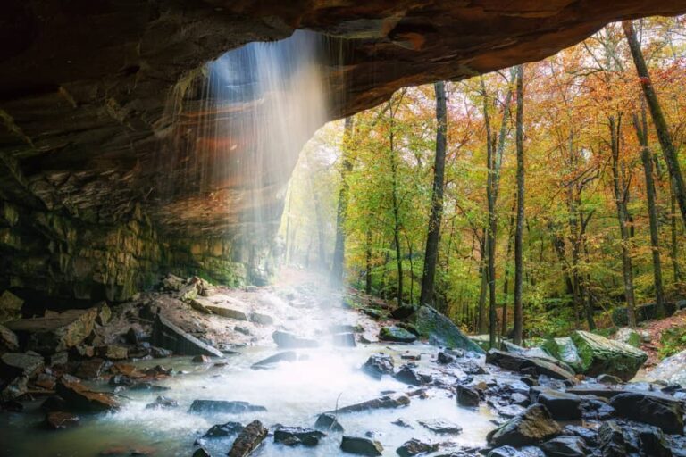
18 miles from Clarksville, the byway meets the Ozark Highlands Trail, a 270-mile east/west route for year-round hiking and backpacking that we’ve mentioned in previous Ozark itineraries. Then, the byway continues another 17.5 miles north to the Glory Hole Falls Trailhead, one of the state’s best known waterfalls. Considered a fairly challenging route, this two mile roundtrip hike leads to a cavern where a creek has worn a large hole through the overhang. Its waters tumble through the opening 31 feet to a pool below. The trek is open all year and the waterfall is particularly pretty during the rainy season and winter when the falls freeze.
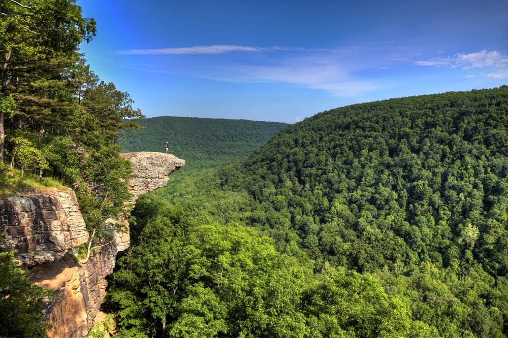
Next, continue 12 miles north on Highway 21 and after crossing the Buffalo River, turn left onto County Road 5. Follow the gravel road another six miles to Hawksbill Crag Trailhead, also called Whitaker Point. You know you’re getting close when about ¼ mile from the small parking area you pass Cave Mountain Church on the right. It’s a moderate three-mile in-and-back hike to perhaps the most iconic spot in the Ozarks. Described by some as “floating above the forest,” Hawksbill Crag is a large chunk of rock that sticks out about 100 feet above a valley. While the view is sensational, walking out on the crag is not for the faint of heart, obviously!
Back on Highway 21, go about a mile north and then continue straight on Highway 43. The road parallels America’s first National River, the Buffalo. Part of the National Park Service since 1972, the river flows freely for 135 miles. It’s one of the last undammed rivers in the Lower 48 states and so recreational opportunities abound. There’s a lot of wildlife, too, including a herd of about 600 elk that live along this section of the byway. Around 1840, elk disappeared from Arkansas. In 1981, the animals were re-introduced to the Buffalo River area, becoming one of Arkansas’s most successful wildlife re-establishment programs. You can learn more about the herd as well as other animals and plants at the Ponca Nature Center, about 4.5 miles from the intersection of highways 21 and 43. There are exhibits, a trail and a gift shop selling souvenirs as well as fishing and hunting licenses.
From the Ponca Nature Center, you can return to Highway 21 and continue about 48 miles north through pretty countryside to the resort town of Eureka Springs, as profiled in our Pig Trail story, above. Or follow Highway 43 northeast 26 miles to Harrison and the start of our story on the Arkansas Scenic 7 Byway. You can also head east of the nature center 14.5 miles on Highway 74 to Jasper and pick up Arkansas 7.
Great River Road – 416 miles from Missouri to Louisiana, including all side trips except to Memphis, Tennessee

Flowing 2,350 miles through the center of America from its headwaters in Minnesota to Louisiana and the Gulf of Mexico, the Mississippi River is the country’s most dominant river, economically, culturally and naturally. “The Delta forms the most important bird and waterfowl migration corridor on the continent and supports North America’s largest wetland area and bottomland hardwood forest.” That’s how the National Park Service describes the Lower Mississippi Delta, the section that runs from southern Illinois and along Arkansas’s entire eastern border to the southeastern tip of Louisiana.
There’s a lot to see along the roads that follow the river as it courses southward. The Mississippi either passes through or forms the borders of 10 states, and the Great River Road is actually one extensive network of scenic byways that run parallel to the Mississippi from headwaters to mouth. In previous articles, we’ve covered Minnesota’s and Iowa’s Great River Roads. Here is Arkansas’s section, which can be explored all year; however, summers are usually very hot and humid.
One challenge with the Great River Road is that as it meanders 362 miles from Missouri to Louisiana, it travels along almost 20 different highways. So follow your road atlas, GPS or phone map app closely. Starting on US 61 at the Missouri state line, the Great River Road heads five miles south to Blytheville. Stop first at the blue-colored Historic Greyhound Bus Depot Visitor Center to admire the restored 1930s Art Moderne building. Inside, in addition to travel information, there are displays on the station’s important role as a transportation hub during the mid-20th century. A five-minute walk from the visitor center leads to the Delta Gateway Museum and exhibits on the cultural and natural history of the Mississippi Delta region, also referred to as the “Arkansas Delta.” For a nature break, head 18 miles west of downtown on Highway 14 to Big Lake National Wildlife Refuge where early 19th century earthquakes turned a free-flowing river system into a large lake and swamp. Big Lake is known for its birdwatching and hunting. More than 225 bird species have been documented, including a sizeable wood duck population, wild turkeys and hundreds and thousands of wintering waterfowl.
Next, from Big Lake National Wildlife Refuge, follow your GPS 19.5 miles southeast to the small town of Osceola, on the banks of the Mississippi. Located on the courthouse square, the Mississippi County Museum has art, memorabilia, furniture, photos and advertisements that document local history. Then, continue south on US 61 as it parallels the Mississippi. In 11 miles you’ll reach Wilson and the Hampson Archeological Museum State Park, which features archaeological treasures from a farming-based civilization that flourished here from about 1400 to 1650. Wilson also has some very contemporary attractions, too, including the upscale Lewis Hotel and two restaurants, the Wilson Cafe and The Grange at Wilson Gardens. Their menus feature locally sourced Southern fare. Most of the thick forests that grew in the rich soil of the Mississippi Delta have been replaced by agriculture. And because much of Arkansas’s farmland is concentrated in the east, the Great River Road passes by fields of the state’s major crops, including corn, cotton, peanuts, rice, soybeans and wheat.
Traveling through farmland on Highway 14, history and country music buffs will want to detour to another attraction that lies 14.5 west of Wilson. The Historic Dyess Colony was a 1930s New Deal-era agricultural resettlement project. Nearly 500 Arkansas families were recruited to live and work there, including Carrie and Ray Cash. Their son would become a country music legend and today, the house is now the Johnny Cash Boyhood Home and Museum.
Back in Wilson, the Great River Road continues south along US 61 for five miles to Bassett. Just before town, look to the right for a historical marker and the remains of a gate. This entrance is pretty much all that’s left of the Bassett POW Camp, which housed some 300 German prisoners during World War II. It was one of several POW camps in eastern Arkansas.
Venturing south of Bassett on US 61, go another 18 miles to Wapanocca National Wildlife Refuge which the U.S. Fish & Wildlife Service describes as “literally an island of forests in a sea of agriculture.” Fishing, hunting, birding and photography are popular at a preserve where the stars are migratory waterfowl, as well as songbirds on their way to and from Central and South America.
Next, following a mix of highways: 77, 50, 218 and finally, US 79, from Wapanocca National Wildlife Refuge travel 63 miles to Marianna. Now, it’s also important to note that you’ll pass very close to Memphis, Tennessee if you’re in the mood for some big city blues, Beale Street, Elvis Presley’s Graceland or the National Civil Rights Museum at the Lorraine Motel, where Martin Luther King Jr. was assassinated in 1968.
Whatever your plans, as you arrive in Marianna one of the first things you’ll notice is Crowley’s Ridge. This unusual geological formation stretches from southern Missouri to east-central Arkansas. It rises some 250 feet above the relatively flat Mississippi Delta. Marianna sits on top of Crowley’s Ridge and a must-stop is Jones Bar-B-Q Diner. Located on the ground floor of Betty and James Jones’s home, this two-table eatery was the first restaurant in Arkansas to receive a coveted James Beard Award, the Oscars of the food world. The diner’s Facebook page sums it up best: “Hours are 7 AM until the food runs out. There is NO MENU. All Jones BBQ Diner serves is a pork BBQ sandwich on Wonder Bread.”
If it’s too early for BBQ or the tables are full, take your sandwiches seven miles east to Mississippi River State Park. Situated in St. Francis National Forest, where Crowley’s Ridge, the Mississippi Delta and Mississippi River meet, the park provides access to numerous adventures, including picnicking, camping, swimming, hiking, biking, kayaking and birdwatching.
From Mississippi River State Park, it’s 28 miles south to Helena, the most interesting city along Arkansas’s part of the Great River Road. Founded in 1820, the city has restored Antebellum and Victorian homes, murals, historic cemeteries, boutiques, Mississippi River canoe tours and Delta Dirt Distillery, a family-owned craft distillery. As the site of the 1863 Battle of Helena, the city has a lot of Civil War history. It was also once a major port on the Mississippi. And when the blues took off in the 1940s and 50s, Helena played a big role. Today, it’s still home to King Biscuit Time, the longest running blues radio show in the country. Every October, the town hosts the world-famous King Biscuit Blues Festival. The exhibits at the Helena Museum of Phillips County and Delta Cultural Center give a full picture of the area’s compelling history.
From Helena, it’s 40 miles west and south following US 49 and Highway 1 to the Dale Bumpers White River National Wildlife Refuge, another prime birding and wildlife watching and hunting destination with about 20 primitive campsites throughout the preserve.
From the wildlife refuge, follow Highway 1 and US 165 south for 37 miles to the Arkansas Post National Memorial. Founded in 1686 near a Native American village, it was the first European and first semi-permanent French settlement in the lower Mississippi River Valley. As described by the National Park Service, “The establishment of the Post was the first step in a long struggle between France, Spain and England for dominance of the Mississippi River Valley.” The Post is also located along the Trail of Tears, the forced relocation of five Native American tribes from their ancestral land in the east to designated territory west of the Mississippi River. Exhibits and artifacts showcase the Post’s significant place in American history.
As you follow Highway 169 west 2.5 miles, Arkansas Post Museum State Park will be at the US 165/Highway 1 intersection. Made up of five buildings, the exhibits explore life in this region of Arkansas from 1877 to today.
Another somber reminder of America’s past is located some 33 miles from the state park following US 165/Highway 1 and then US 65 south to McGehee. During World War II, more than 8,000 Japanese Americans were detained at the Rohwer Japanese American Relocation Center between 1942 and 1945. The WWII Japanese American Internment Museum has artifacts, photographs and background information on Rohwer’s history. There’s not much left of the actual camp but to see it, follow Highway 1 northeast of McGehee 12.8 miles. The museum recommends referring to it as “Rohwer Relocation Center Memorial Cemetery” if using Google Maps.
From the Relocation Center, follow Highway 1 and then Highway 4 south to Arkansas City. Once a thriving port on the Mississippi with a peak population of about 15,000, a major flood wiped out most of the city in 1927. Today, fewer than 500 people live here but a walking tour reveals seven buildings lovingly refurbished and now listed on the National Register of Historic Places.
From Arkansas City, follow Levee Road south along the Mississippi River about 24 miles to Lake Chicot State Park where the centerpiece is the largest natural lake in Arkansas and the biggest oxbow lake in North America. So, it’s no surprise that Lake Chicot is a favorite with birders and those who fish for largemouth bass, crappie, bream and catfish. The park has 85 campsites and 14 cabins, and you can rent boats and take lake and levee tours. At the visitor center, ask how to drive on top of the levee for notable views of the water, swamp, wildlife and farmland.
From the state park, it’s about 7.5 miles south to Lake Village and then another 12 miles to Lakeport Plantation. Like all Delta plantations, Lakeport was built by enslaved laborers. Preserved, restored and owned by Arkansas State University, the Greek Revival home still has many of its original architectural features. Exhibits throughout the house and grounds tell stories of slavery, sharecropping and the family who formerly owned the plantation. You can explore Lakeport on your own or take a guided tour. From the plantation, it’s another 27 miles south to the Louisiana border.
