Overlooked and underappreciated, there’s a lot to be discovered in North Dakota. Tucked away in the Upper Midwest, this out-of-the-way state is one of America’s least visited. It’s frequently mentioned as the last to reach by travelers “collecting” all 50 (West Virginia was my final state to pick up, by the way!) But North Dakota boasts 63 national wildlife refuges, the most of any state. It also has 11 wetland management districts, 13 state parks, a national park and the International Peace Garden. So, if you like the outdoors, North Dakota delivers. The state’s scenic byways concentrate on its natural treasures while also highlighting North Dakota’s robust history and Native American heritage. Fewer visitors mean less crowded highways and attractions. And since it’s so far north, there’s plenty of daylight to enjoy the state’s warm summers.
- Western North Dakota: Theodore Roosevelt National Park
- Sakakawea Trail
- Killdeer Mountain Four Bears
- Sheyenne River Valley – National Scenic Byway
- Turtle Mountain Byway & International Peace Garden
Western North Dakota: Theodore Roosevelt National Park – 330 miles

This road trip picks up where the Native American Scenic Byway ends, as featured in our previous South Dakota article. The route enters North Dakota south of Fort Yates and then continues another 75 miles to Bismarck, the state capital. From Bismarck, start heading west 133 miles to Medora. The quickest, most direct and least scenic way is via I-94. If you have time, try driving the Old Red Old Ten Scenic Byway which parallels I-94 for some 90 miles from Mandan (immediately west of Bismarck) to Dickinson. The name comes from the Old Red Trail that ran from New York to Seattle. The trail eventually became Highway 10. The drive passes through numerous small towns with museums, eateries and shops. Highlights include 38-foot-high Salem Sue, the “World’s Largest Holstein Cow.” Overlooking New Salem, the giant fiberglass sculpture honors the dairy industry. In Dickinson, the 12-acre Dickinson Museum Center is known for its Badlands Dinosaur Museum and Prairie Outpost Park, featuring several relocated historic structures. The freeway is never too far away so you can jump on I-94 whenever you want.
Another worthy detour is the Enchanted Highway. From Bismarck, it’s 88 miles on I-94 west to Gladstone. The Old Red Old Ten Scenic Byway also passes north of town and Dickinson is 12 miles further west. The Enchanted Highway starts in Gladstone and runs 32 miles south to Regent. Along the drive are some of the world’s largest scrap metal sculptures with descriptive names like Geese in Flight, World’s Largest Tin Family, Teddy Rides Again, Pheasants on the Prairie, Grasshoppers in the Field, Deer Crossing and Fisherman’s Dream. Looking to revive his hometown of Regent after decades of economic and population decline, Gary Greff began constructing the artwork in 1989. Then, he opened the Enchanted Castle Hotel in 2012. Nearby, there’s a gift shop with miniatures of the sculptures. Regent also has a campground.
From Dickinson, follow I-94 another 37 miles west through farmland and prairie to Medora and the entrance to Theodore Roosevelt National Park. The park has two units. The northern section is 68 miles away and we’ll get to that shortly. This is the South Unit which has a visitor center, campground and the 36-mile Scenic Loop Drive. Parts of the loop are narrow with sharp curves and steep grades. That said, large RVs and vehicles with trailers are allowed.
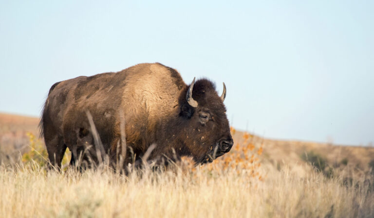
The national park’s story began more than 65 million years ago when ancient rivers deposited sediments from the emerging Rocky Mountains. Erupting volcanoes across the West add ash. This layer cake of rock was then carved and eroded by modern rivers along with help from snow, ice, rain and wind. Today, the process continues and as you drive, bike and hike through these badlands, you’re greeted by colorful cliffs, domes, buttes and pillars. It’s a striking contrast to the surrounding Great Plains. Native Americans first called this area “mako sica” which means badlands. French traders called it a “bad land to travel.” Keep watch for bison, pronghorn, elk, white-tailed and mule deer, wild horses, bighorn sheep and prairie dogs.
In 1883, a young Theodore Roosevelt arrived in the Dakota Territory to hunt bison. Over the years, he returned many times, challenged physically and mentally. His evolving love and appreciation for this part of the country transformed America. “I would not have been President had it not been for my experience in North Dakota,” he later said. During his time in office, Roosevelt established five national parks and helped found the U.S. Forest Service, crafting a conservation policy that continues to endure.
To reach the park’s North Unit, from Medora follow I-94 east to US 85 north. It’s 68 miles to a small visitor center. If you’re traveling from early to mid-August through early September, you’ll likely see fields of sunshine on the drive between units. These enormous plantings of blooming sunflowers are found throughout North Dakota in late summer.
The North Unit gets fewer visitors but is no less spectacular. Following Scenic Drive for 14 miles, the road passes several viewpoints, trailheads and a campground before dead ending at Oxbow Overlook. Hiking, backcountry hiking, birding and wildlife watching are popular. Scenic Drive is almost entirely paved and is open to RVs and cyclists. The closest fuel, food and lodging is in Watford City, 15 miles north of the visitor center on US 85.
Sakakawea Trail – 200 miles
As a guide and interpreter, Sacagawea was an instrumental part of the Lewis and Clark Expedition that explored the American West. In North Dakota, she’s more commonly called Sakakawea, after whom this byway is named. Running from the western part of the state to the center, this road trip features several Lewis and Clark-related attractions toward its eastern end. The route starts where US 85 and North Dakota Highway 200 meet, 20 miles south of Theodore Roosevelt National Park’s North Unit and about 50 miles northeast of Medora and the national park’s South Unit. The closest community is Grassy Butte, five miles north.
From the US 85 intersection, ND 200 heads east 21 miles, arriving in Killdeer, known for a rodeo and nearby battlefield site. It’s also where the Killdeer Mountain Four Bears Scenic Byway starts; see the article below for more info on Killdeer. The town has fuel, restaurants and a couple of campgrounds.
Continuing east, in six miles ND 200 reaches Lake Ilo National Wildlife Refuge, a large feeding and nesting area for migrating birds, including cormorants, ducks, herons, pelicans, Canada geese, bald eagles, American kestrels and great horned owls. There’s also fishing and picnicking. A couple of miles east, poke your head into the free Dunn County Museum in Dunn Center. The “Historical Diamond of the Western Prairies” provides a solid introduction to local history and includes a Western Room, large machinery exhibit and replica log cabin and homesteader’s shack.
The landscape begins to flatten eastward as buttes, ravines and prairie give way to farmland. Oil is also important to the economy. In 42 miles you’ll reach the turnoff for Beulah followed soon by Hazen, two of the larger towns along the route with many services. Six miles past Hazen, take a left and follow ND 200 as it heads north. In 18 miles the highway reaches Lake Sakakawea State Park, which sits on the south shore of imposing Lake Sakakawea. It’s the third largest reservoir in the U.S., after Lake Mead and Lake Powell in the Southwest. Formed by the damming of the Missouri River, Lake Sakakawea is 180 miles long and nearly 14 miles wide in spots. The park juts into the lake and offers camping, hiking and spectacular water views. Swimming, sail boating and windsurfing are big as well as relaxing on the beach, playing volleyball and fishing for walleye, northern pike and chinook salmon. The park is also the western start for the North Country National Scenic Trail. Crossing eight states on the way to Vermont, the trail stretches 4,800 miles and is the longest in the National Trails System.
The park is within eyesight of Garrison Dam, completed in 1953. It’s about three miles to the visitor center which has displays and power plant tours. There’s also a fish hatchery, open to the public. For more birding, photography, wildlife watching and hunting opportunities, Riverdale State Game Management Area and Audubon National Wildlife Refuge are both nearby. Audubon is much more developed with a visitor center, Prairie Nature Trail and the eight-mile South Shore Auto Tour Route. The wildlife refuge sits on Lake Sakakawea and features wetlands and prairie grasslands. And if you’re feeling civilized, there’s even a winery in the area: Wolf Creek offers tastings and tours by appointment only.
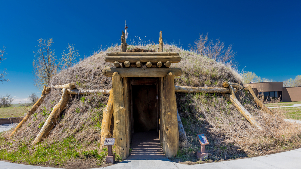
From Lake Sakakawea State Park, backtrack 10 miles on ND 200 and then take a left onto County Road 37. It’s another 10 miles to Knife River Indian Villages National Historic Site, which is directly south of Garrison Dam as the crow flies. Located along the Missouri River with the Knife River running through it, the site preserves a major trade center for Native Americans who lived in this area for more than 11,000 years. After 1750, it became important to the fur trade. French-Canadian Toussaint Charbonneau lived here with his wife, Sakakawea. Born in present-day Idaho as a Lemhi Shoshone, she was likely taken captive at age 11 or 12 by a Hidatsa raiding party. The Hidatsas lived at Knife River. Starting in 1804, Lewis and Clark interacted extensively with the Hidatsas and another tribe, the Mandans. The explorers hired Charbonneau as an interpreter and Sakakawea joined the expedition, too. She became invaluable because of her knowledge about the land, people and languages farther west. At the museum, displays, artifacts and decorative arts of Northern Plains Indians detail the history. On the grounds, you can walk the remains of three Hidatsa villages, a garden and reconstructed earth lodge. To learn more about earth lodges, see the Killdeer Mountain Four Bears entry below.
It’s another 10-mile drive southeast along the Missouri River to Fort Clark State Historic Site, considered one of North Dakota’s most important archeological locations. A place of commerce and tragedy, Fort Clark Trading Post and Primeau’s Post once bustled. The Mandan and then later, Arikara people lived and traded here. Their communities were decimated by smallpox and cholera epidemics. The site protects the remains of a large earth lodge village, cemetery and the two fur trade posts.
From Fort Clark, it’s about 14 miles on ND 200 to Washburn, a small town on the north shore of the Missouri River with two more significant historical attractions. Managed by the National Park Service, the Lewis and Clark Interpretive Center goes into great detail about the Corps of Discovery. In 1803, the Louisiana Purchase was bought from France, doubling the size of the U.S. Then, President Thomas Jefferson chose Meriwether Lewis to lead the Corps of Discovery through the new territory and Lewis asked William Clark to join.
From the Interpretive Center, it’s about three miles west to the Fort Mandan Historic Site, a fully furnished, life-size replica of the winter quarters Lewis and Clark built in November 1804. They stayed until April 1805 and during that time met with the Mandan and Hidatsa and hired Charbonneau and Sakakawea to continue with them on the expedition. Fort Mandan’s true location is on private land several miles west of the reproduction and so you can’t see the actual site. All of the places on this road trip that involve the Corps of Discovery are part of the Lewis and Clark National Historic Trail. Starting in Pittsburgh, Pennsylvania, it winds nearly 4,900 miles through 16 states and more than 60 tribal nations to the Pacific Ocean.
From Fort Mandan Historic Site, go back to Washburn, cross over the Missouri and continue south to Cross Ranch State Park. It’s about 11 miles total. After learning about the Mandan, Hidatsa, Lewis, Clark and Sakakawea, this 589-acre park and adjacent 6,000-acre Cross Ranch Nature Preserve offers a sense of what it must have been like. Cross Ranch lies along some of the last undeveloped, free-flowing stretches of the Missouri River. There’s camping, fishing and hiking on nearly 17 miles of trails which you can cross-country ski and snowshoe in the winter. The preserve features river bottom forests, woody draws, mixed prairie grass and roaming bison. So be wary! You can rent canoes and kayaks and the park will arrange to transport you, for a fee.
The byway ends here but Bismark is less than an hour south. The state capital has shops, galleries, wine bars, breweries, museums and even the Lewis and Clark Riverboat for summer cruises on the Missouri.
Killdeer Mountain Four Bears – 80 miles

This byway in west-central North Dakota has a little bit of everything: Mandan, Hidatsa and Arikara culture, a massive lake, a rodeo and perhaps the state’s best scenery. Referencing our two previous itineraries, this byway starts in Killdeer, 41 miles southeast of Theodore Roosevelt National Park’s North Unit and 35 miles directly north of Dickinson. Killdeer is also located on the west-to-east Sakakawea Trail but this road trip heads north. Killdeer is a small town with a big cowboy tradition. For a hundred years, it’s hosted the Killdeer Mountain Roundup Rodeo in July. It’s North Dakota’s longest-running professional sanctioned rodeo. Throughout the summer, there are smaller events, too, if you’d like to see a rodeo but can’t make the famous one.
From Killdeer, go 2.5 miles north of town and then head west 7.5 miles to the Killdeer Mountain Battlefield State Historic Site where U.S. troops fought the Sioux in July 1864. According to the State Historical Society of North Dakota, “This attack on an Indian trading village in the Killdeer Mountains was one of a series of military reprisals against the Sioux that followed the US-Dakota War of 1862 in Minnesota.”
The Killdeer Mountains are two large, flat-topped buttes rising several hundred feet above the surrounding plains. The area is peaceful and hilly with oak and birch trees and abundant wildlife. Native Americans called it tah-kah-o-kuty, “the place where we kill deer.” From the battlefield site, continue another 20 miles northeast to Little Missouri State Park. Along the route, the topography gives way to badlands, those rugged, rounded, multihued hills sculpted by erosional forces that define Theodore Roosevelt National Park. The Sioux named this area Mako Shika, “where the land breaks.” Some consider Little Missouri Breaks Country to have North Dakota’s most outstanding scenery and photogenic state park.
With more than 45 miles of trails, Little Missouri State Park is great for hiking. The park also welcomes horseback riding with corrals and a round pen. Some trails follow the Little Missouri River, an eye-catching ribbon of blue meandering through the badlands. There are both modern and primitive campsites.
From the park, the byway heads into the Mandan, Hidatsa and Arikara Nation, also called the Three Affiliated Tribes. It’s 46 miles north to New Town, which lies on Lake Sakakawea, America’s third largest reservoir created when the Missouri River was dammed. New Town is about midway along the lake and accessible via the mile-long Four Bears Bridge, the longest bridge in North Dakota with a design honoring 19 tribal chiefs. New Town has restaurants, fuel and a casino. The marina has RV sites, showers, a boat dock and ramp. For the best water and bridge views, head to Crow Flies High Butte Overlook.
Opened in 1964, the Three Affiliated Tribes Museum commemorates the heritage, lifestyle and art of people who once dominated the Great Plains. The ceremonial garb and beadwork are particularly memorable. History lovers take note that the museum also lies near where the Lewis and Clark Expedition passed through in the spring of 1805. The Earth Lodge Village is another unique attraction. Over hundreds of years, the Mandan, Hidatsa and Arikara mastered agricultural and building techniques in a climate where winters are particularly brutal. Constructed to accommodate multiple families, earth lodges were circular and 30 to 60 feet across. The reconstructed village features a main lodge surrounded by smaller ones. The site is self-guided but contact the Three Affiliated Tribes directly to learn about cultural events such as powwows. From New Town, it’s 70 miles west to Williston and 74 miles northeast to Minot, the largest and closest cities.
Sheyenne River Valley – National Scenic Byway – 85 miles
Pastoral and picturesque, the Sheyenne River Valley is classic Midwest beauty. Showcasing the rolling topography of southeastern North Dakota, the byway starts near Valley City, an easy drive on I-94 from Bismarck, 135 miles west and Fargo, 61 miles east. From Valley City, drive 11 miles north to Baldhill Dam and Lake Ashtabula with prime fishing, boating, swimming and picnicking. Spring and fall bring migrating waterfowl and winter means ice fishing and snowmobiling. Famous for its sunsets, the 70-acre Mel Rieman Campground and Recreation Area has 27 campsites.
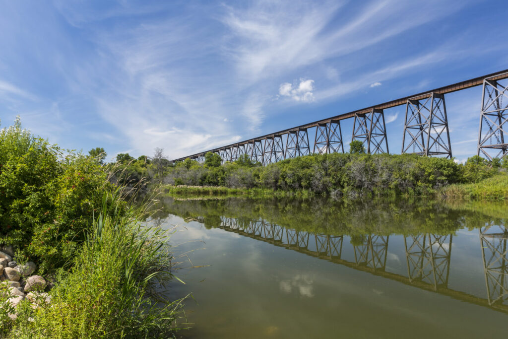
Baldhill Dam marks the byway’s official beginning, as the road parallels the Sheyenne River south. From here, follow River Road to Valley City with coffee houses, restaurants, boutiques and a brewery. The Rosebud Visitor Center is helpful and includes info on the town’s eight distinct bridges, all crossing the Sheyenne. The most outstanding is Highline Bridge, one of the highest and longest railroad spans in the U.S. The campus of Valley City State University has the 30-acre Medicine Wheel Park. What started as a class project in 1992 has grown into one of North Dakota’s major tourist attractions. It features Native American burial mounds and a colossal rock sculpture. With a 213-foot circumference and 28 spokes radiating from its center, the Medicine Wheel represents Earth’s journey around the Sun and the cycle of the seasons.
The road trip then leaves town, crossing I-94 and heading south on County Road 21. About four miles out of town, look for the Riparian Restoration Interpretive Site on the Sheyenne riverbank to the right. It has a picnic area and native plant arboretum. There’s also a canoe and kayak launch.
The rich farmland produces corn, soybeans, barley and wheat. And prepare to be awed by vast fields of blooming sunflowers from early to mid-August through early September. Nature’s bounty is also on display at Clausen Springs Recreation Area, 17 miles south of the Riparian Restoration Interpretive Site. Getting there involves a detour west off the byway. A lake is the centerpiece of this 545-acre wildlife management area where activities include camping, hiking, swimming, fishing, boating, canoeing, kayaking and birding. We mentioned the North Country National Scenic Trail in the previous entry on the Sakakawea Trail Scenic Byway. Well, on its way to Lake Sakakawea from Vermont, the 4,800-mile North Country trail follows the northern boundary of Clausen Springs.
From Clausen Springs it’s seven miles east to Kathryn. Go a mile east of town to snap a photo of Wadeson Cabin. The state historic site preserves a hand-hewn oak log cabin built in 1876. The postcard-worthy cutie has been a community hall, country store, pioneer home and icehouse.
An appealing contrast to Clausen Springs lies 5.5 miles south of Kathryn. Woodsy 27-acre Little Yellowstone Park lies in the hills and valley along the Sheyenne River. Camping and forest hikes are what you do here and like much of the scenery along this byway, the park’s fall colors are some of the state’s finest.
From Little Yellowstone it’s a five-minute drive east to Standing Rock Historic Site where four interconnected burial mounds sit on a hill overlooking the Sheyenne River. Built by Native Americans during the Woodland period, these burial mounds are 1400 to 2100 years old, and according to the State Historical Society of North Dakota, one mound can contain the remains of up to 35 people.
From Standing Rock, it’s 20 minutes south to Fort Ransom State Park, another natural beauty along the North Country National Scenic Trail. The woods are the main draw, accessible via 20 miles of trails for hiking, biking, cross-country skiing and snowshoeing. Horseback riding is also encouraged and the park has 68 corrals and other amenities to accommodate equestrian users. There’s canoeing, kayaking and fishing on the Sheyenne as well. Of course, you can camp but the park also offers several types of unique lodging, including a pioneer homestead house, constructed in 1879, and a homey covered wagon with beds and air conditioning. The Sodbuster Building hosts the annual Sodbuster Days celebration with homesteading life demonstrations and exhibits.
From the state park it’s a couple of miles south to Fort Ransom, founded in 1878. The tiny town’s T.J. Walker Historic District includes the remains of a mill and adjacent dam, store, house, large barn and ice storage building. Continue another mile west to Fort Ransom State Historic Site which was established by the U.S. government in 1867 to protect overland travel from Minnesota to Montana. The fort was dismantled in 1872 but the building locations and dry moat are still visible. The byway ends 17 miles east in Lisbon, a small town with fuel, groceries and pizza.
Turtle Mountain Byway & International Peace Garden – 45 miles

Covered with ash, poplar and oak with numerous lakes, the Turtle Mountains are a beautiful, popular destination in northcentral North Dakota and southwestern Manitoba. They lie within the traditional territory of the Plains Ojibwe and are part of the Métis homeland, too. Rising 300 to 400 feet above the surrounding prairie, the mountains run 20 miles north/south and 40 miles east/west. This short byway follows the Turtle Mountains along the Canadian border, ending at a world-renowned garden that gives North Dakota its nickname, the Peace Garden State.
From Minot, the closest city in the region, it’s 80 miles northeast to Bottineau, a small town with all the necessities. Plus, it’s where you’ll find Tommy the Turtle. More than 26 feet tall, he’s the world’s largest snowmobile-riding turtle. And so, this road trip begins.
From Bottineau, it’s six miles north to Turtle Mountain State Recreation Area with more than 12 miles of trails for off-highway vehicles, hiking, biking, snowshoeing and horseback riding. Another six miles and you reach 7,500-acre Turtle Mountain State Forest with more trails through woods, wetlands and grasslands. With good views of farmland to the west, Mystical Horizons Scenic Overlook has structures built to observe the equinox and summer and winter solstices. Nicknamed the “Stonehenge of the Prairie,” it also features a working sundial.
From the state forest, go 11 miles east to Lake Metigoshe State Park. With several lakes and unique habitats, you’ll see plants, animals and birds seldom found elsewhere in North Dakota. Camping, hiking, mountain biking, kayaking, canoeing and stand up paddleboarding are summer activities. Winters are popular, too, with cross-country skiing, snowshoeing, sledding, fat tire biking and ice fishing.From Lake Metigoshe it’s another 19 miles to the International Peace Garden. It lies in both the United States and Canada, on the world’s longest international border. Established in 1932, the garden is a symbol of peace and friendship between the two countries. The brainchild of an Ontario horticulturist and teacher, the garden’s location was chosen because it’s near the geographical center of North America. To build the park, Manitoba donated 1451 acres and North Dakota purchased and donated 888 acres. Featuring flowers, shrubs, trees and statues, the garden welcomes more than 200,000 visitors a year. To enter, you’ll need a passport or government-issued ID and a copy of your birth certificate. Minors can visit with a birth certificate. Peak bloom is mid-July through August and yes, the International Peace Garden has a campground.
