Virginia holds a special place in American history. In 1607, Jamestown became North America’s first permanent English settlement. George Washington led the Continental Army and became the first U.S. president. The third U.S. president, Thomas Jefferson, was the main author of the Declaration of Independence. Both were Virginians. The Revolutionary War was won in Yorktown. And that’s just what happened up to the early 1800s. Meanwhile, the commonwealth is home to Shenandoah National Park and spectacular Appalachian scenery to the west. To the east are beaches and coastal tidelands. Collectively, these five byways are some of the nation’s most prominent roads.
- Skyline Drive – Shenandoah National Park – All-American Road
- Blue Ridge Parkway – All-American Road
- Journey Through Hallowed Ground Byway – National Scenic Byway
- Colonial Parkway – All-American Road
- George Washington Memorial Parkway – All-American Road
Skyline Drive – Shenandoah National Park – All-American Road – 105 miles
70 miles west of downtown Washington, DC, the town of Front Royal is the northern starting point for Skyline Drive. You can journey this road in either direction but our story goes north to south, where the highway then becomes the Blue Ridge Parkway, profiled in the article that follows.
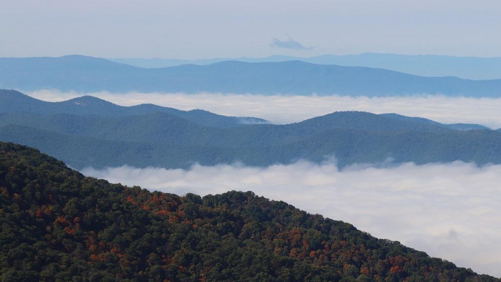
Virginia’s west is mountainous, with the Blue Ridge paralleling the commonwealth’s border with West Virginia. Shenandoah National Park lies in northwestern Virginia. A long and narrow park, it encompasses almost 200,000 acres and features 500 miles of trails.
Skyline Drive runs the length of Shenandoah National Park, and while you can join it from a couple of intersecting highways along the way, Skyline is the only road fully accessing the park top to bottom. So, it can get crowded, particularly on weekends for spring wildflowers and fall colors. Getting there early helps, too, although mornings can be misty, obscuring the impressive vistas. Of course, nothing puts you closer than staying onsite and Shenandoah National Park has five campgrounds. Backcountry camping is allowed with a permit.
After the entrance station where you’ll pay a fee, Skyline Drive begins climbing. For the next 100 miles, it follows a narrow ridge along the summit of the Blue Ridge Mountains. Five miles from the entrance you’ll reach the first of two visitor centers, Dickey Ridge. The second visitor center is in Big Meadows, about halfway along the route. Both offer information, bookstores, maps and restrooms. Several hiking trails are accessible from the visitor centers, too.
As Skyline Drive weaves along the spine of the mountains, the views from either side are predictably fantastic, with numerous colorfully named overlooks like Gooney Run, Hogwallow Flats and Little Devils Stairs. Starting about 600 feet above sea level, Skyline Drive reaches its peak elevation, 3,680 feet, at Skyland. Continue another four miles to the Hawksbill Loop Trailhead where a 1.6 roundtrip hike leads to the summit of 4,050-foot-high Hawksbill Mountain, the park’s highest point.
Another trek to consider, at least to say you’ve been on it, is the Appalachian Trail, the world’s most famous hiking footpath. It runs parallel to Skyline Drive for 90 miles and can be accessed at numerous points.
There are also trails to several different waterfalls, including the popular 70-foot Dark Hollow Falls, a 1.4-mile roundtrip hike. It’s four miles there and back to see Rose River Falls’ dazzling 67-foot cascade. At 93 feet, Overall Run Falls is the park’s tallest waterfall, but it’s a trek: five miles round trip. Seasonal water flow varies so check ahead to make sure the falls you want to see are worth the effort.
McCormick Gap is the last overlook before Skyline Drive exits Shenandoah National Park, turning into the Blue Ridge Parkway as it intersects I-64. The journey continues below.
Blue Ridge Parkway – All-American Road – 469 miles, 217 in Virginia
Website: https://www.blueridgeparkway.org/
The Blue Ridge Parkway is one of America’s most famous scenic byways, connecting two iconic national parks: Shenandoah in the north to Great Smoky Mountains in the south. Crossing two states, this article covers the Virginia section of the parkway, from Shenandoah National Park to the North Carolina border. Look for the Tar Heel State’s part in our upcoming North Carolina article.
Driving south on Skyline Drive and leaving Shenandoah National Park (see article above), the highway intersects I-64 and becomes the Blue Ridge Parkway at Rockfish Gap. From here, Charlottesville is 24 miles and Richmond is 92 miles east on I-64. At the Rockfish Gap junction, there’s a welcome kiosk and parking area, notable because this is also an intersection for the Appalachian Trail, the world’s longest hiking-only footpath. It passes through 14 states as it heads up the Appalachian Mountains from Georgia to Maine. More miles of the trail go through Virginia than any other state. At times, the trail and Blue Ridge Parkway run very close to each other and cross, giving hikers the chance to experience the Appalachian Trail in several spots.
The Blue Ridge Parkway isn’t your typical road. 45 mph is the maximum speed and commercial vehicles aren’t allowed. There’s no fuel along the parkway, either. Instead, when a highway intersects the parkway, it’s called an access point and gas stations, convenience stores, fast food and other shops are usually nearby. There are seasonal campgrounds on the parkway and just off it are many privately-owned campgrounds open year-round. The Blue Ridge Parkway maintains a helpful website with maps and attractions, including a section that lists EV charging stations.
In 1933, President Franklin D. Roosevelt visited Shenandoah and the idea was born to connect the newly built Skyline Drive to Great Smoky Mountains National Park. Construction began in 1935 but the parkway’s continuous 469-mile route wasn’t fully completed until 1987.
The Blue Ridge Parkway is numbered with mileposts, starting with zero at Rockfish Gap, where Skyline Drive becomes the Blue Ridge Parkway, and ending with Milepost 469 in Cherokee, North Carolina. They help to locate points of interest and access points.
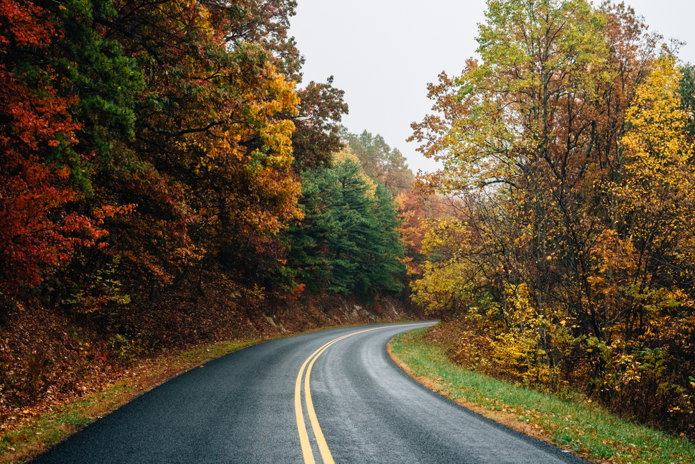
The two-lane parkway is meant to be leisurely explored, its main attraction being the endless scenic views of the Appalachians. Here are some of the Blue Ridge Parkway’s top sights in Virginia, from Skyline Drive to the North Carolina border, including their mileposts.
- Humpback Rocks and Historic Mountain Farm – Milepost 5.8: The parkway climbs sharply to a visitor center with a short hike to rock outcroppings. There’s also a collection of historic buildings moved here from nearby locations.
- For the next 55 miles, there are about 30 pullouts with views as captivating as their names, including Dripping Rock, The Slacks, Bald Mountain, Stillhouse Hollow, Boston Knob and Chimney Rock Mountain.
- Otter Creek area and James River Visitor Center – Milepost 60: There’s a lot going on here: streams, lakes, a campground and many opportunities for hiking, fishing and wildlife viewing. At 649 feet and flowing through a gorge, the James River is also the lowest point of the parkway. The visitor center has a picnic area, trails and exhibits on the nearby Kanawha Canal, a Civil War supply route.
- Apple Orchard Mountain – Milepost 76.5: From its lowest point, over the next 13 miles the parkway climbs to its highest elevation in Virginia. There are no apples here. At 3,950 feet, punishing winter winds make northern red oaks look like gnarled apple trees. Go another two miles to Sunset Field Overlook where a trailhead leads to the 200-foot Apple Orchard Falls, one of Virginia’s most impressive waterfalls.
- Peaks of Otter – Milepost 85.6: With Abbott Lake in the foreground and mountain peaks behind, the tranquil setting is reason enough to pull over. The Peaks of Otter Lodge, a living history farm and occasional mountain music concerts make this a particularly popular stop. There’s also a visitor center, campground and more hiking and fishing.
- Roanoke: From Peaks of Otter, it’s about 20 miles to this large city with grocery stores, hospitals and doughnut shops as the parkway cruises through the Roanoke River Basin.
- Mabry Mill – Milepost 176: The parkway climbs from the river basin to the Blue Ridge Plateau, weaving through picturesque farmland of vegetables, tobacco, hay and wine grapes. Mabry Mill adds to the rural Appalachia setting with its waterwheel, cultural demonstrations, a country fare restaurant and Sunday afternoon music and dancing.
- Groundhog Mountain – Milepost 188.8: In addition to many picnic sites, the highlight is the large, old log observation tower and its panoramic views. There are also several styles of historic log fences on display with information on their purpose and benefits. The exhibit dates to 1939.
- Blue Ridge Music Center – Milepost 213: Open May through October, this free museum and visitor center celebrates the region’s rich musical traditions of bluegrass, old-time, folk, Americana, country blues and gospel. Live music happens on the covered breezeway from noon to 4 pm. There’s also a summer concert series every Saturday evening from Memorial Day through Labor Day. You’ll need to purchase tickets for the Saturday evening events. From the music center, it’s about five miles to the state line. We’ll continue along the Blue Ridge Parkway in our North Carolina article, coming soon.
Journey Through Hallowed Ground Byway – National Scenic Byway
Named after the words made famous in President Abraham Lincoln’s 1863 Gettysburg Address, the Journey Through Hallowed Ground Byway connects several significant historic sites as it travels north from Virginia and into Maryland before ending in Gettysburg, Pennsylvania.
The byway starts in Charlottesville, an hour west of Richmond. With an historic downtown surrounded by rolling hills, farmland and wineries, Charlottesville is an attractive area to set up camp. It’s home to the University of Virginia and both Shenandoah National Park’s Skyline Drive and the Blue Ridge Parkway lie 30 minutes west, as profiled above.
Southeast of Charlottesville is Monticello, Thomas Jefferson’s home, plantation and presidential library. Jefferson was the primary writer of the Declaration of Independence and served as the nation’s third president, from 1801 to 1809. A World Heritage Site, Monticello was another one of Jefferson’s masterpieces, from the mansion to the gardens, where he experimented with different plants. And though he wrote “all men are created equal,” more than 400 enslaved people lived and worked at Monticello during Jefferson’s lifetime.
Just outside Monticello is Michie Tavern, serving buffet lunches made from 18th-century Southern recipes. The 1784 Pub is open Friday and Saturday afternoons. The building dates to the 1780s and was moved to its current location in 1927.
From Monticello, follow Virginia State Route 20 northeast about 30 miles to another presidential property. Montpelier was home to James and Dolley Madison, who were also slave holders. The fourth U.S. president’s mansion and plantation feature exhibitions, gardens and trails.
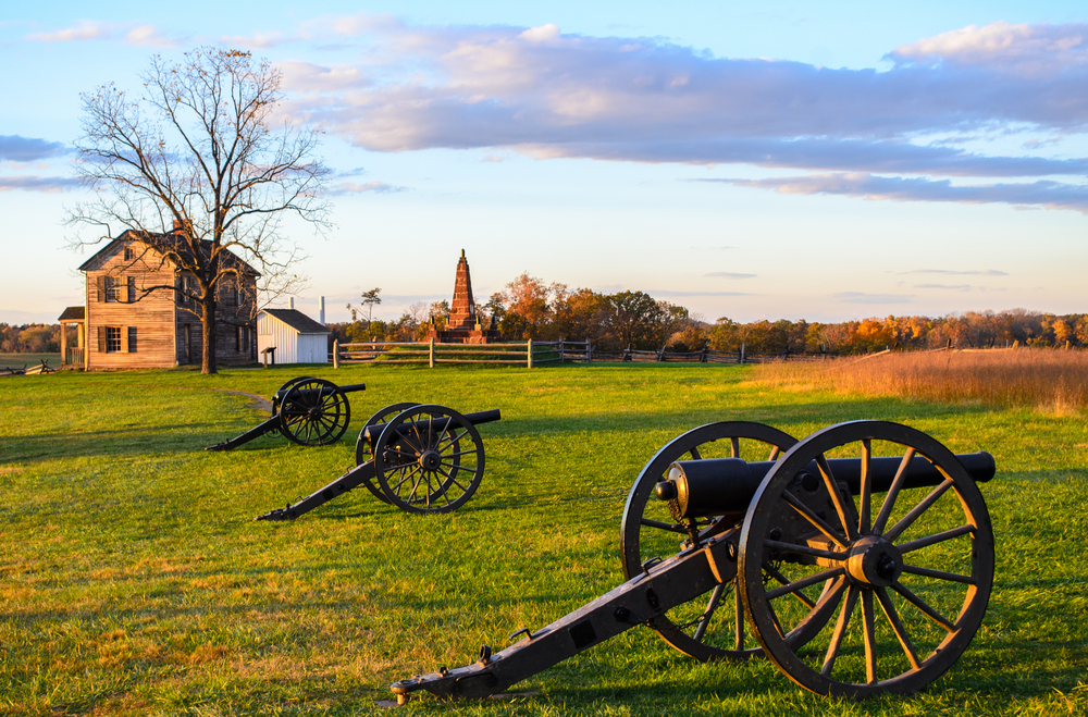
From Montpelier, it’s five miles to Orange. As you drive Main Street, look for the uniquely designed courthouse, built in 1858. Then, go north on US 15 and east on US 29 another 60 miles to Manassas National Battlefield Park where the Battle of First Manassas took place in 1861. Also called the First Battle of Bull Run, it was the initial full-scale conflict of the Civil War, won by the Confederates. Manassas is just 30 miles west of Washington, DC, close enough for U.S. senators to witness the war in person. A year later, and under the leadership of General Robert E. Lee, the South crushed the North again in the Battle of Second Manassas, also called the Second Battle of Bull Run. Stop at the visitor center first and then walk the trails or take the driving tour.
Following VA 234 back to US 15, it’s about 20 miles north to Oatlands, another former plantation open to visitors. Now a National Historic Landmark, there are guided tours of the mansion. The grounds feature a 4.5-acre formal garden, America’s second oldest greenhouse and a 1903 carriage house.
Next up: Leesburg, 10 minutes north of Oatlands. With shops, galleries, restaurants and breweries, the town is a modern respite from all the heavy history. Still, the 19th-century house and gardens of Dodona Manor are worth a look. It’s the former home of General George C. Marshall who led the U.S. Army to victory in World War II, and then developed the Marshall Plan which helped rebuild western European economies after the war.
Northeast of town and overlooking the Potomac River is a small but significant 1861 Civil War battle site. Ball’s Bluff Battlefield Regional Park features one of the country’s smallest national cemeteries, interpretive markers and hiking trails.
Back on US 15, the highway crosses the Potomac River and into Maryland at Point of Rocks. There’s an historic, photogenic railway station here as well as St. Paul’s Church. During the Civil War, Union troops used the church as a hospital and for cooking. This is also the intersection of the east/west Chesapeake & Ohio Canal Scenic Byway, as featured in our Maryland article.
The Journey Through Hallowed Ground Byway continues north. Another major Civil War site is a 23-mile side trip. Northwest of Point of Rocks is Antietam National Battlefield where 23,000 soldiers were killed, wounded or went missing on September 17, 1862. The “bloodiest one-day battle in American history” ended the Confederate’s first invasion into the Union.
From Antietam, it’s 24 miles east to Frederick. Or, if you decide to skip the side trip, from Point of Rocks continue north on US 15. In 13 miles you’ll reach Frederick, another attractive town with a 50-block historic district. Rose Hill Manor Park & Museums, National Museum of Civil War Medicine, South Mountain State Battlefield Park and Monocacy National Battlefield are worthwhile stops. At Monocacy, Federal troops thwarted a plan by the Confederacy to capture Washington, DC and manipulate the 1864 election. Though outnumbered three to one, Union soldiers held on until reinforcements arrived.
North of Frederick, Catoctin Mountain Park offers camping, hiking, fishing and cross-country skiing. It’s also where the presidential retreat Camp David is located, which isn’t open to the public.
Back on US 15, it’s ten miles to the Pennsylvania state line and then another six miles to Eisenhower National Historic Site. Here, you can tour the home and grounds of the 34th President. Dwight and Mamie Eisenhower used their farm as a weekend retreat and meeting place for world leaders.
The Eisenhower estate borders the byway’s final stop, Gettysburg National Military Park. Considered one of the most consequential battles in American history, Gettysburg marked the turning point of the Civil War. Over three days in July 1863, the Union defeated the Confederates. More than 51,000 soldiers were killed, wounded or went missing, making Gettysburg the bloodiest single conflict of the war. The park is a large site and there’s a self-guided driving tour, walking trails and a cemetery. The visitor center has exhibitions and information, plus scheduled times for artillery demonstrations. The town of Gettysburg offers a lot, too, including many restaurants and camping options.
Colonial Parkway – All-American Road – 23 miles
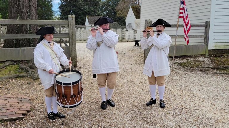
The Colonial Parkway is one of America’s most significant scenic byways. It represents European colonization and the birth of a world superpower. Native American tribes were changed forever. And Virginia’s economy developed and profited from slavery for almost 250 years. Just 23 miles long, the parkway connects three major American historical sites: Jamestown, Williamsburg and Yorktown.
Today, the city of Williamsburg is a top tourism destination. Located in southeastern Virginia next door to Newport News, it’s three hours south of Washington, DC and an hour east of Richmond. If you’re coming from Virginia’s capital city, State Route 5 will take longer but it’s a very pretty drive that follows the James River.
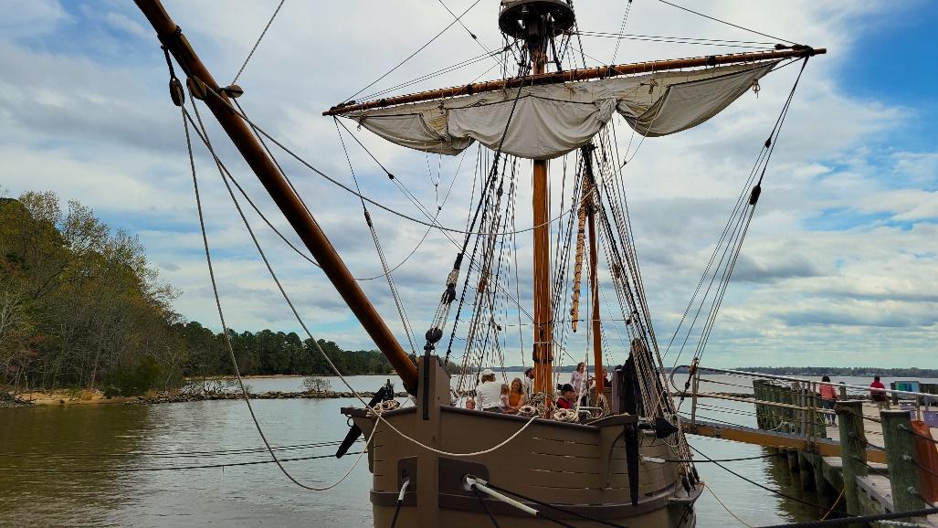
The Colonial Parkway starts southwest of Williamsburg in Jamestown. In 1607, English colonists sailed up the James River, landed on James Island and founded Jamestown, named for King James the First, ruler of England at the time. A five-mile loop drive around the small island shows what the harsh environment was like: marshy, heavily forested, hot and humid summers, icy cold winters.
Today, there are two sections to visit. Jamestown Settlement focuses on life in 17th-century Virginia. Galleries include portraits, documents, toys, furnishings, tools, weapons and ceremonial and decorative objects. Jamestown Settlement is also a living history museum where performers in period costume, called interpreters, forge in a blacksmith shop, make wood and leather products, sew and cook meals. In addition to a re-created fort and Powhatan Indian village, replicas of Discovery, Godspeed and Susan Constant, the three ships that brought the first Englishmen, are docked nearby.
Jamestown Settlement is a good setup for the other section, Historic Jamestowne, where the original 104 colonists, all men, founded the first permanent English settlement in North America. The archaeological site overlooks the James River, and you can wander past excavated buildings, peer into current digs and walk through the rebuilt church. Its brick tower is the only surviving above-ground structure from 17th-century Jamestown. An indoor museum, The Archaearium, exhibits arms and armor, tools, coins, tobacco pipes, religious objects, food remains and Virginia’s largest collection of colonial period American Indian artifacts.
Between Historic Jamestowne and Jamestown Settlement is the Glasshouse, where you can watch modern glassblowers create 17th-century-inspired objects, which are then available for purchase.
From Jamestown, the Colonial Parkway passes through wetlands and woodlands on the 10 miles to Williamsburg. Completed in 1957, the parkway itself is a national treasure. Built by the National Park Service, this meticulously crafted, two-way road has no center line. It’s also designed to preserve the natural landscape so it looks much as it has throughout history. Thus, both modern city and historic Williamsburg can barely be seen from the parkway.
Colonial Williamsburg is big, featuring more than 500 original and reconstructed buildings and 90 acres of gardens and green spaces. In 1699, the colonial capital was moved from Jamestown to Williamsburg. Then, in 1780, Virginia’s capital moved again, this time west to Richmond. The Revolutionary War was underway and leaders, including Governor Thomas Jefferson, thought Williamsburg was more vulnerable to British attack.
The city evolved into a quiet backwater, a fading beauty filled with decaying historic structures. In the 1920s, the movement began to restore Williamsburg to its 19th-century glory. Today, it’s the largest living history museum in the U.S. with costumed interpreters demonstrating cabinetmaking, blacksmithing, wig making, candle making and many other crafts using historically accurate tools and methods. There are roving fiddlers, fife and drum corps and actors portraying Thomas Jefferson, Martha Washington, Gowan Pamphlet (the first-known ordained Black Baptist preacher) and Oconostota, a Cherokee leader.
Over the years, Williamsburg has been criticized for whitewashing slavery and ignoring colonization’s impact on Native Americans. Some think it feels like an amusement park. Even so, there’s no cost to walk the streets and see for yourself. Admission is only required to enter buildings and experience programs.
Williamsburg also includes more than 70,000 pieces of art. Some are on display in town while others are found at two extraordinarily photogenic museums, housed in the same complex and adjacent to the historic area. The DeWitt Wallace Decorative Arts Museum showcases 17th- through early 19th-century textiles, metals and clocks. It also includes the world’s largest collection of American South furniture and one of the biggest assemblages of British ceramics outside England.
Quirky and playful are themes in the 7,000 pieces displayed at the Abby Aldrich Rockefeller Folk Art Museum. From the 18th century to present day, art is in the eye of the beholder from tobacconist and carousel figures to quilts, paintings, pottery and toys. Admission to both is included in a Colonial Williamsburg ticket.
Continuing east on the Colonial Parkway, it’s twenty minutes to the Yorktown Battlefield, the final major fight of the Revolutionary War. Designed to be driven, the battlefield has a clearly marked vehicle tour. Walking trails lead through batteries, past cannons and across redoubts. In 1777, the French joined the Americans’ battle for independence. In the fall of 1781, General George Washington’s troops and his French allies trapped British forces at Yorktown. Two days later the British gave up the fight at Surrender Field. The United States officially gained freedom at the Treaty of Paris in 1783.
The American Revolution Museum at Yorktown is also a must-see where leg shackles from slave ships, weaponry, portraits, life-size statues and numerous period artifacts chronicle the times. Outdoors, there’s another living history museum with a working, Revolution-era farm. The re-created Continental Army encampment features musket demonstrations.
With so many dates, locations and famous names to digest, it takes a solid two or three days to fully explore this historic triangle. There are numerous campgrounds in the Williamsburg area and obviously, the earlier you book, the closer to the main attractions you’ll be. Summer and other times when school is out are busiest. Pricing at the sites and museums is complicated, too, so research before you go.
George Washington Memorial Parkway – All-American Road – 25 miles
This byway has some of the best views and attractions in the nation’s capital and yet it never runs inside Washington, DC. Instead, from George Washington’s home in the south, this short road trip follows the Potomac River north to Theodore Roosevelt Island, directly across from downtown DC, before ending at I-495. And though it connects numerous historic sites, parks and wildlife areas, this urban byway can get crowded during rush hour.
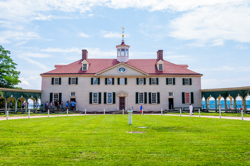
Starting 16 miles south of the National Mall and Washington Monument, Mount Vernon is the plantation and mansion of America’s First President, George Washington. He and Martha are buried here, along with many other family members. You can tour the house, gardens, farm, slave quarters, Slave Memorial and family tomb. Admission also includes working reconstructions of Washington’s distillery and gristmill, a three-mile drive from the estate’s main entrance.
From Mount Vernon, it’s a five-minute drive to Fort Hunt Park. Completed in 1898, it was built to complement the older Fort Washington, which stands across the Potomac River in Maryland. As you walk around Fort Hunt, you’ll see the batteries constructed to defend the river approach to Washington, DC. The fort was used as a German POW camp during World War II.
Another two miles north following the Potomac leads to River Farm, headquarters for the American Horticultural Society. Founded in 1922, it’s kinda like the U.S. capital of plants with a mission to “share with all Americans the critical role of plants, gardens and green spaces in creating healthy, livable communities and a sustainable planet.” River Farm was once one of George Washington’s five farms. Today, it features formal and naturalistic gardens, including woodlands, a meadow, orchard and children’s gardens. Admission is free.
From River Farm, it’s two miles north to Dyke Marsh Wildlife Preserve. A favorite with birders, there’s a short hiking trail but it’s best explored by boat. With 485 acres of tidal marsh, floodplain and swamp forest, Dyke Marsh is one of the largest remaining freshwater tidal wetlands in the DC area.
From the wilderness of Dyke Marsh, it’s just three miles to Alexandria, founded in 1749. The waterfront city was once the location of America’s largest domestic slave trade. Tobacco was sold here, too, and Alexandria was also a supply center for Union troops during the Civil War. Today, Old Town Alexandria is known for cobblestone streets, restored 18th- and 19th-century buildings and numerous shops, restaurants and museums. In 2022, it placed #4 in Condé Nast Traveler’s Best Small Cities in the U.S. followed by Travel + Leisure’s 50 Best Places to Travel in 2023.
As it moves through Alexandria, the parkway is simply called Washington Street. North of the city, the byway regains its name. Like the Colonial and Blue Ridge parkways (see articles above), a lot of thought and care went into designing the George Washington Memorial Parkway. The Virginia countryside is prominently featured and another example lies just north of Alexandria. 106-acre Daingerfield Island juts into the Potomac River and is popular with walkers, joggers and birders.
The parkway then passes Ronald Reagan Washington National Airport and if you’re into planespotting, Gravelly Point is where hobbyists go for ear-splitting, sublime views of jets landing and taking off.
The Pentagon is next, on the left. The prominent landmark is the headquarters of the United States Department of Defense and it’s also the world’s largest low-rise office building. The Pentagon isn’t directly accessible from the parkway, but it’s worth the short detour to see the Pentagon Memorial honoring those who died when terrorists crashed American Airlines Flight 77 into the building on September 11, 2001. That day is doubly significant because exactly 60 years before, on September 11, 1941, builders broke ground for the Pentagon’s construction. Guided tours inside the Pentagon are only offered to U.S. citizens and just on Tuesdays and Thursdays. You must register at least two weeks in advance.
From the Pentagon, spectacular views of the Washington skyline are on the right while the next major attraction is on the left. Arlington National Cemetery is the final resting place for about 400,000 veterans and their eligible dependents, representing the Revolutionary War to today’s conflicts. Arlington’s 639 acres are also home to gravesites for astronauts, supreme court justices and two presidents, William Howard Taft and John F. Kennedy. The Welcome Center, Arlington House and Tomb of the Unknown Soldier, where the Changing of the Guard takes place, are other notable sites within the cemetery.
Up the parkway and on the right, a parking lot leads to a pedestrian bridge and Theodore Roosevelt Island, a memorial and nature preserve dedicated to the 26th President of the United States. The Swamp, Woods and Upland trails are popular for walking and birding. Fishing is allowed but bikes aren’t.The parkway ends eight miles farther, at I-495. Before the intersection, Turkey Run Loop Road leads to more trails and public restrooms along the Potomac River. And, if you’d like to drive the Chesapeake & Ohio Canal, as featured in our Top 5 Scenic Byways in Maryland article, take I-495 across the river where the Clara Barton Parkway follows the north side of the Potomac.
