Let’s be honest: for many travelers, Oklahoma is not top of mind when it comes to road tripping. Well, unless you’re just zooming through on the three major interstates that intersect in Oklahoma City: I-35, I-40 and I-44. But if you get off the freeways, slow down and drive the smaller roads, you’ll discover the state has a diverse topography with prairies, forests, mountains and lakes, as well as many state parks that provide access and amenities to enjoy nature. Oklahoma also has a particularly complex Native American and pioneer history. Starting in the 1830s, the U.S. government drove the Cherokee, Chickasaw, Choctaw, Creek and Seminole off their lands in the southeastern states. Called the Trail of Tears, the grueling, deadly forced relocation led to land that became Oklahoma. Then, in 1889, the Oklahoma Territory was opened to pioneer settlement through land claim races. Those who jumped the gun when the pistol was fired were called Sooners. Today, the Sooner State’s heritage is showcased in many ways along the byways, and Oklahoma’s food and music scenes are pretty enjoyable, too. One major byway not included is Historic Route 66 which travels through a big part of Oklahoma on its way from Chicago to Los Angeles. That road trip is so revered that we’ll profile Route 66 in its entirety in a separate upcoming article.
- Talimena Scenic Drive – National Scenic Byway
- Cherokee Hills Byway – National Scenic Byway
- Wichita Mountains Byway – National Scenic Byway
- Black Mesa
Talimena Scenic Drive – 54 miles, from Talimena State Park east to Mena, Arkansas + 27 miles if starting at Choctaw Capitol Museum in Tuskahoma
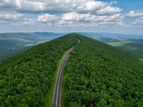
This short but very pretty National Scenic Byway straddles two states with about two-thirds in Oklahoma and the other third in Arkansas. “Talimena” is derived from the towns on either end: Talihina, Oklahoma and Mena, Arkansas. Specifically constructed in the 1960s to show off the area’s best views, the paved route starts in southeastern Oklahoma and leisurely winds east through the Ouachita Mountains. The ridges and valleys are thickly covered with pine, oak, dogwood and other species that make up Ouachita National Forest, the largest and oldest national forest in the southern US. So, understandably the drive is particularly stunning and popular during spring bloom and fall color change.
A good starting point for this road trip is in Tuskahoma at the Choctaw Capitol Museum. One of the major tribes forced by the US government to leave its lands in the 1830s, the Choctaw followed the Trail of Tears from the southeastern US to Oklahoma. The museum has exhibits on the tragic move as well as other cultural and historical displays featuring traditional pottery, clothing and tribal documents. It’s located in the restored building that housed the Choctaw Nation’s government from 1884 to 1907.
From the museum, drive 27 miles east on US 271 through the town of Talihina to Talimena State Park near the byway’s official start. Many hiking and backpacking trails through Ouachita National Forest take off here, too. The park also has 10 RV sites, seven designated tent campsites, a picnic pavilion and gift shop. Dirt bikes and ATVs are permitted, too.
Then, just past the park on US 271, take a right onto State Highway 1 and the official start of Talimena Scenic Drive. You’ll also find a visitor information station here. The byway heads east through Winding Stair Mountain National Recreation Area with more camping and hiking trails. There are numerous pullouts with expansive views of the rolling terrain. About 22 miles from the byway’s start, stretch your legs and learn about the forest on three short interpretive trails at the Robert S. Kerr Arboretum and Nature Center.
From the nature center, it’s 13 miles to the state line where the byway crosses into Arkansas and becomes State Highway 88. About three miles farther, the graves of two dozen homesteaders are located in Pioneer Cemetery. Another 1.5 miles is The Wonder House, a stone home built in the 1930s that’s listed on the National Register of Historic Places. Located in Queen Wilhelmina State Park, the house can be toured with a guide. The park has camping, picnicking and hiking but the best known attraction is the lodge, the third hotel in this spot. The first was built to accommodate railroad passengers and since the railway was mainly funded by Dutch investors, the luxury hotel was named in honor of Queen Wilhelmina of the Netherlands. The “Castle in the Sky” opened in 1898 but then closed in 1910 and quickly deteriorated. In 1963, a smaller lodge was constructed on the site but burned to the ground ten years later. The current facility opened in 1975, was renovated in 2015 and features 40 rooms, Southern cuisine in the Queen’s Restaurant and superb views from atop Rich Mountain. At 2,681 feet, it’s the second highest peak in Arkansas and great for stargazing; thus, Queen Wilhelmina is also a registered Dark Sky park.
For something more down home, from the lodge go 2.5 miles east to Rich Mountain Country Store, following Highway 88 and then veering left onto Highway 272. Serving breakfast anytime plus burgers and ice cream, the shop sells souvenirs and has an RV park.
Back on the byway and Highway 88, go a couple of miles to the Rich Mountain Fire Tower, the highest point on the drive. You can’t climb the tower, but the views are still fantastic.
With names like Grand View, Round Mountain and Blue Haze, the last few vistas make a memorable ten mile drive from the fire tower and into Mena, the largest town along the byway. Local history is on display at the Kansas City Southern Historic Depot & Museum, a restored train depot that’s also home to the chamber of commerce. Mena has many restaurants, a developing art scene with several galleries and even the nearby Board Camp Crystal Mine where you can dig for quartz crystals and take home what you find.
Cherokee Hills Byway – 93 miles, from West Siloam Springs south to Gore
Two features stand out with this National Scenic Byway: First, it fronts the western side of one of America’s most famous mountain ranges, the Ozarks. This route in northeastern Oklahoma runs through the Ozark foothills, where the grasslands of the Great Plains meet the Ozark Mountains. The landscape features prairies, rivers, lakes and cliffs as it meanders north to south. Second, there’s a lot of Native American history here. The byway is in the Cherokee Nation, home to people whose ancestors were forced by the US government in the 1830s to leave their homeland in the southeast, traveling west along the Trail of Tears to “Indian Territories” that eventually became the State of Oklahoma.
The Cherokee Hills Byway starts in West Siloam Springs at Oklahoma’s border with Arkansas, 31 miles northwest of Fayetteville and 82 miles east of Tulsa. Following US 59 west, from West Siloam Springs it’s six miles to Natural Falls State Park where the namesake attraction cascades 77-feet over a rocky bluff into a pool below. Natural Falls is Oklahoma’s highest waterfall, and the park offers picnicking, camping and five yurts for rent. The lush environment supports ferns, mosses and liverworts while maples, oaks and dogwoods grow in the forest, so it’s also a hiker’s and botanist’s paradise.
From Natural Falls, continue west on US 59 for seven miles and then head south on State Highway 10, where the byway curves through the Cookson Hills near the Illinois River, considered one of the prettiest waterways in Oklahoma. The river is also prized for canoeing, kayaking, rafting and tubing. About 20.5 miles down Highway 10, look for Illinois River Outfitters which rents equipment and riverside tent camping sites.
Continuing south on Highway 10 and then west on US 62, it’s 7.5 miles to Tahlequah, a small city that’s also the capital of the Cherokee Nation. After Congress passed the Indian Removal Act in 1830, the Cherokee were forced to move west. Now with a worldwide population of more than 450,000, the Cherokee Nation is the largest tribe in the US. More than 141,000 citizens live within the Cherokee Nation’s reservation boundaries in northeastern Oklahoma.
Today, Tahlequah has a diverse population of 17,000. You’ll find a variety of restaurants, from burgers, BBQ and pizza to Italian, Chinese, Mexican, Cajun and Creole. There are numerous hotels and RV parks in the area. Authentic Cherokee arts and crafts can be found at the Cherokee Nation Gift Shop and at the Cherokee Arts Center’s Spider Gallery. Dating back to 1842, Tahlequah also has the oldest main street in Oklahoma, and so it figures there are a few historical sites worth checking out. Located in the beautifully restored Cherokee National Capitol building, the Cherokee National History Museum has galleries and exhibits covering hundreds of years of tribal history and culture. Built in 1844, the Cherokee National Supreme Court Museum is the oldest government building in Oklahoma with many historical objects, photos and furniture. The Cherokee National Prison Museum is another interesting stop. It opened in 1875 and held “the most hardened criminals in Indian Territory.” There were even plantations on Cherokee land. Today, Hunter’s Home is a National Historic Landmark and living history museum that demonstrates what life was like at Oklahoma’s only remaining pre–Civil War plantation home.
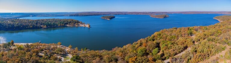
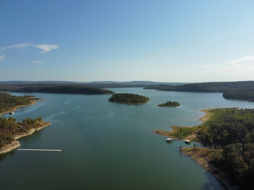
Leaving Tahlequah, the byway then visits a series of excellent state parks. Heading south on US 62 and then Highway 82, it’s 13.5 miles to Cherokee Landing State Park. Sitting on a peninsula, the park lies at the north end of Lake Tenkiller, considered one of the most beautiful lakes in Oklahoma, if not the country. Rocky bluffs and a woodsy 130-mile long shoreline surround nearly 13,000 acres of emerald blue water. Though it’s a smaller park, Cherokee Landing has very desirable camping because it juts into the lake, so the views are particularly terrific. Watersports, hiking and birdwatching are prime activities. The park also has a volleyball court and 9-hole disc golf course.
From Cherokee Landing, the byway and Highway 82 follow the lake’s eastern shore 18 miles south to Tenkiller State Park. With 38 cabins, 10 campgrounds, 172 picnic tables, an outdoor swimming pool, volleyball and basketball courts plus the Driftwood Nature Center and floating Clearwater Café, Tenkiller is a lot busier than Cherokee Landing! Located at the southern end of Tenkiller Lake, boating, waterskiing, tubing, fishing and hiking are big. And because the water is incredibly clear, scuba diving is a major draw. Tenkiller Scuba Park has a sunken airplane, helicopter, school bus, two boats and lots of fish. Away from the scuba park, there are natural underwater areas to explore as well as the remains of homesteads and artifacts covered when the reservoir filled around 1950. For scuba equipment rental, training and certification, Gene’s Aqua Pro and Nautical Adventures are two shops located close by.
From Tenkiller the road trip veers away from the lake about 12 miles west to Greenleaf State Park. This beauty is less busy than Tenkiller but also offers a multitude of pastimes, from hiking and camping to miniature golf, volleyball and basketball. The park’s 16 cabins and several other facilities are made of native stone and were built in the 1930s by the Works Progress Administration. The park lies on Greenleaf Lake, a reservoir that drains into the nearby Arkansas River. So, there’s a lot of water around here and fishing is a major hobby and sport.
Which brings us to Gore, the final stop on the Cherokee Hills Byway, nine miles south of Greenleaf State Park. Called “The Trout Capital of Oklahoma,” the town lies near where the Illinois River flows into the Arkansas and attracts fishermen who also seek striped bass, walleye and paddlefish. Gore has a small main street with a few shops and restaurants. Then, cross the Arkansas River and go four miles to I-40.
Wichita Mountains Byway – 44 miles, from Lawton to the western boundary of Wichita Mountains Wildlife Refuge – 138 miles driving the full byway to Carnegie and back to Lawton

This National Scenic Byway explores the varied terrain of southwestern Oklahoma, highlighted by the Wichita Mountains, a wildlife refuge and the museums of Fort Sill and Lawton. This small city makes a good home base with restaurants, stores, hotels and a couple of casinos. There are RV parks, too, but you might want to wait for camping along the scenic byway.
Oklahoma has a fascinating history and Lawton’s Museum of the Great Plains provides a good overview chronicling ancient times to pioneer settlement and modern day. The region is home to the Comanche Nation, too, and some 7,000 members live in the tribal jurisdictional area around Lawton and nearby counties. A five minute walk from the Museum of the Great Plains is the Comanche National Museum and Cultural Center with artifacts, historical and cultural displays and the world’s most complete collection of Comanche fine art. The gift shop is pretty cool, too.
Directly north of Lawton is Fort Sill, an army base particularly well-known for artillery training. There are two on-site museums. The collection at the U.S. Army Artillery Museum dates back to 1775 and includes guns, gear, ammunition and uniforms. Nearby, the Fort Sill National Historic Landmark and Museum encompasses 38 buildings containing some 235,000 objects. Displays focus on the fort’s founding, mission and evolution, from the 1860s forward. Another worthy site inside Fort Sill is Geronimo’s Grave & Beef Creek Apache Cemetery, the final resting place for Apache POWs including chiefs, warriors, scouts and their families. Geronimo is also buried here. Known for fiercely protecting his people, the Apache leader and medicine man spent the last 23 years of his life as a prisoner of war before he died in 1909. Because all of these sites are on the military base, anyone 16 and older must complete FS Form 118a and pass a background check before entering.
From Lawton and Fort Sill, head north on I-44 about six miles to State Highway 49 and the byway’s official start. Drive west another six miles to Medicine Park. The Plains Indians were first to enjoy the area’s tranquility. Then, in 1908 the oasis became a town and Oklahoma’s first resort community, attracting gangsters, celebrities and politicians. Today, relaxation is still the focus with restaurants and shopping. Native red rocks give many of Medicine Park’s structures a distinctive look. The town’s centerpiece is Bath Lake, a man-made swimming hole with waterfalls. The Medicine Park Aquarium and Natural Sciences Center has more than 90 native and non-native fish, reptile, amphibian, bird and mammal species and a six-acre botanical garden. For lodging, there are cottages, cabins, bed and breakfasts, as well as great camping just to the north at Lake Lawtonka. With 21 miles of shoreline, it’s another popular swimming spot with a beach, boating, fishing and other water activities.
The lake’s water flows from the Wichita Mountains, lumpy granite-topped hills that rise from the rolling grasslands northwest of Lawton. Driving west of Medicine Park, Highway 49 immediately enters Wichita Mountains Wildlife Refuge where herds of bison, Rocky Mountain elk and Texas longhorn roam. But hundreds of other species of mammals, birds, reptiles, fish, insects and plants live on the refuge’s 60,000 acres, too. One of the refuge’s best overlooks is from the top of 2,464-foot Mount Scott. It sits just west of Medicine Park so about two miles from the aquarium, look for Mount Scott Road to the right and take the short detour for excellent views.
Back on Highway 49, go three miles west and then take a right onto Highway 115 north. In about a mile, look for the Parallel Forest, a weirdly peaceful (some would say haunted) 16-acre plot of red cedars, growing exactly six feet apart from each another in parallel lines. It’s said the 20,000 trees were planted to moderate the effects of the Dust Bowl. Rumors abound about this odd fabricated forest, including why there’s a mysterious circular stone structure located near the back.
In addition to this strange forest, the Wichita Mountains are also known for their rocks, such as those red cobblestones used in Medicine Park’s construction. From Parallel Forest, one of the most impressive architectural displays made from local stone is two miles away. Returning a mile to Highway 49, go right and then take another right to Holy City of the Wichitas, a 66-acre replica of ancient Jerusalem. Most of the structures were built in the 1930s and tours are offered by appointment. There’s also a chapel, museum and gift shop. And every spring, Holy City puts on North America’s longest continuously running Easter pageant.
A mile south of Holy City, a short trail leads to the Lake Jed Johnson Tower, another structure made of indigenous rock. While you can no longer climb the 60-foot observation tower, it’s an attractive feature of the lake, which offers boating and fishing. Returning to the main highway, keep in mind that the Wichita Mountains Byway is essentially a loop route, with spur roads. Later, we’ll drive north on the loop, but now, continue west on Highway 49/115 and look to the right for the Ingram House and then a short distance farther for Ferguson House, two more interesting structures made of cobblestones. About five miles after leaving Holy City, you’ll see the entrance to the Quanah Parker Nature and Visitor Center. Built on the shores of Quanah Parker Lake, this area is the heartbeat of the refuge with restrooms, a gift shop and information on camping, picnicking, hiking, fishing, mountain biking, rock climbing and rappelling. The visitor center also has exhibits on geology, wildlife and habitats as well as periodically offering nature and wildlife tours. Nearby, the Doris Campground has 47 tent and 23 RV sites.
From the visitor center, it’s another 10 miles on Highway 49 before the route exits the wildlife refuge. Along the way are more hiking trails and a prairie dog town. The colony has recently been repopulated after falling on hard times so check conditions at the visitor center. About a mile past the prairie dogs, look for NW Indiahoma Road where a left turn leads to the Bison Trail, perhaps the refuge’s best hike where a six-mile loop leads through forests, grassland, across a river and past a canyon. Back on Highway 49, for more camping and recreational opportunities, continue west (drive straight when Highway 49 turns into E 1570 Road at the intersection with Highway 54) for 12 miles to Great Plains State Park on the banks of Tom Steed Lake.
If you’re heading farther west in Oklahoma, consider traveling along Highway 44 north from Blair to Lone Wolf, about an hour west of Quanah Parker Nature and Visitor Center. This drive passes through the Quartz Mountains, an extension of the Wichita Mountains. Lake Altus-Lugert is the route’s gem attraction and Quartz Mountain State Park provides countless water- and shore-based activities as well as wide-ranging accommodations. One of Oklahoma’s original seven state parks, Quartz Mountain has a lodge, restaurant, cabins and five camping areas.
So, back to the looping part of Wichita Mountains Byway which we referenced earlier. Return east on Highway 49 and then go north on Highway 115 to the Parallel Forest. Continuing north, the byway meanders past Saddle Mountain, named for the dip between two peaks. In 32 miles, Highway 115 dead ends but the byway continues seven miles east on Highway 9 to Carnegie where you’ll find fuel, food and the Liberty Theater, Oklahoma’s oldest continually operating cinema that still shows first-run films while serving topnotch hot dogs. From Carnegie, the byway heads south on Highway 58 through the Slick Hills toward Lawton, about 42 miles away.
Black Mesa & the Oklahoma Panhandle – 108 miles, from Boise City to Black Mesa State Park and Picture Canyon, Colorado then back to Black Mesa State Park
This scenic drive in the Oklahoma Panhandle is a treasure hunt for dinosaur tracks, geological formations and American Indian rock art so it makes a fun excursion for kids. Before you head out, mark a map and then start collecting sites. First stop is Boise City, an isolated little town where several major highways converge. The closest big city for miles is Amarillo, Texas, about two hours south. Outside the Cimarron Heritage Center sits Cimmy, an 18,000 pound, 65-foot-long and 35-foot-high iron dinosaur that’s a scale model of an Apatosaurus. Nearby is a huge replica of the Tin Woodman from the Wizard of Oz. The area’s long history is told through exhibits on dinosaurs, ranching, the Santa Fe Trail and Dust Bowl. There’s also the lone bomb that didn’t explode in 1943 when Boise City was mistakenly targeted by a B-17 bomber during a World War II training exercise. The other five practice bombs did explode but no one was killed. The heritage center is also a good place to ask questions and pick up maps and brochures for this road trip.
After grabbing a bite at Farmhouse Café, head west on State Highway 325 about twenty miles and stop to read the plaque indicating where the Santa Fe Trail passed by. Connecting western Missouri to Santa Fe, New Mexico, the trail functioned mainly as a commercial route from 1821 to 1880. Then, continue driving north on Highway 325 a short way before taking a left and following the signs or GPS another seven miles to Black Mesa State Park. This pinyon pine and juniper oasis lies in rolling hills with Lake Carl Etling at its heart. Camping, boating, kayaking and fishing for largemouth bass, flathead catfish, walleye and smallmouth bass are popular. The park is also classified as Bortle 1, meaning it has some of Earth’s darkest skies for stargazing and astrophotography.
From the park, continue north about 4.5 miles where the road reconnects with Highway 325. Go right and as you’re heading east, look for two unusual eroded sandstone formations: The Old Maid to the north of the highway and soon after, The Wedding Party to the south. In another three miles, a quick hike leads to selfie opportunities with a life-size dinosaur femur. The concrete reproduction stands sentry over a quarry where an Apatosaurus was excavated in the 1930s. Dinosaur fossils are plentiful in this area: over the years, eighteen tons of bones have been quarried.
To see real dino footprints, return west seven miles west on Highway 325 to Black Mesa Road. A right turn and five miles lead to another right turn where a short drive on gravel along Carrizo Creek arrives at a dinosaur track site. Some 150 million years ago a theropod left footprints that are still clearly visible in the sandstone. It’s thought the giant reptile was an Allosaurus although the exact species is unknown. The tracks are on private property, but you can look at them during daylight hours.
In nearby Colorado, an ancient volcano exploded about 30 million years ago and one of the lava flows ended in Oklahoma. Black Mesa is named for the layer of black lava rock that coated the flat-topped hill, and it looms a short distance from the dinosaur tracks. Black Mesa is the eastern-most extension of the Rocky Mountains and boasts the Sooner State’s highest elevation at 4,973 feet. As the area where the Rockies meet prairie shortgrass and the Great Plains, plants and animals are at their westernmost and easternmost ranges. This unique setting is a 1,600-acre nature preserve that’s a favorite with birders. You might also spot bighorn sheep, black bear, bobcat, mountain lion, mule deer or pronghorn. There’s no camping on the reserve but you can hike. A favorite trail leads to the top of Black Mesa where a pillar marks Oklahoma’s highest point.
From the Black Mesa parking area, it’s about five miles north to another distinctive spot, the tripoint where Oklahoma, Colorado and New Mexico meet. While vehicles and cattle roam through the hilly landscape today, in the mid-1800s this region was a sanctuary for outlaws. As the official website of the Oklahoma Senate describes it, “In 1850, Congress established the boundaries for Texas, Kansas and New Mexico. When they finished, they were shocked to discover a parcel of land unclaimed by any territory. Congress declared it ‘neutral’ or ‘No Man’s Land’ and promptly forgot about it. The result was a strip of land 167 miles long and nearly 35 miles wide without any kind of government or law.” Today, this No Man’s Land is part of the Oklahoma Panhandle, and at the tripoint there’s another pose-worthy pillar where you can stand in three states.
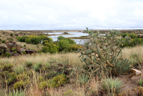
Most of this road trip unfolds in Cimarron County, the western-most county in Oklahoma that forms the end chunk of the panhandle. It’s also the only county in America that borders four states: Texas, New Mexico, Colorado and Kansas. While there are a lot of fun facts to share with the kids, the treasure hunt ends in Colorado with ancient artwork. Using your GPS and following a series of paved and dirt roads situated mostly in Colorado, it’s 24 miles north, east and then south to Picture Canyon, an amazing location that looks more like the American Southwest than Great Plains.
Picture Canyon lies just a few miles north of the Oklahoma border in the Comanche National Grassland. Thirteen miles of hiking and horseback trails explore shallow sandstone canyons, rock formations, natural springs and rolling hills. It’s another great area for bird and wildlife watching. For thousands of years, people have thrived in this area as evidenced by rock art, stone tools, charred bones, dwelling rubble and the remnants of early 20th century homesteads. Some of the most intriguing examples are an easy hike from the parking area to a canyon wall. Dating back to the 1600s or early 1700s, Plains Indian cultures carved petroglyphs and painted pictographs of animals, human figures and abstract designs some believe might represent the stars. Sadly, a lot of graffiti has been carved into the rock, too, so it’s both a marvel and sobering experience. There’s no camping in Picture Canyon and so it’s about 31 miles back to Black Mesa State Park.
