Maryland is one of the most distinctly shaped states. Chesapeake Bay takes up a big chunk of its eastern side. To the west, at one point Maryland gets so narrow that less than two miles separate its northern neighbor, Pennsylvania, from West Virginia to the south. Maryland’s unique boundaries and geographical variety mean road trips here are a complex and fascinating mix, particularly if you love early American history, the ocean and mountains.
- Chesapeake Country – All-American Road
- Chesapeake & Ohio Canal
- Baltimore’s Historic Charles Street – National Scenic Byway
- Harriet Tubman Underground Railroad Byway – All-American Road
- Religious Freedom Byway – National Scenic Byway
Chesapeake Country – All-American Road – 300 miles

Maryland’s Eastern Shore is completely separated from the rest of the state by the Chesapeake Bay and Susquehanna River. It’s actually part of Delmarva, a peninsula including all of Delaware and a section of Virginia at the southern end. Unlike Maryland’s middle which is dominated by big cities and politics – Baltimore, Washington, DC and Annapolis – the Eastern Shore is rural and laidback. Corn and soybean farms are punctuated with small towns. There are wildlife refuges and a few wineries. It’s beautiful and relaxing.
This byway starts in Chesapeake City, halfway between Baltimore and Philadelphia, both about an hour away. In 1829, the Chesapeake & Delaware Canal opened, connecting Chesapeake Bay and Delaware Bay. Every year, more than 25,000 ships cruise the 14-mile-long canal, about 40% of all Atlantic Ocean traffic heading into Baltimore, making the C&D one of the world’s busiest canals. Chesapeake City’s refurbished 19th century architecture, B&Bs, shops, cafes and marinas are a top tourist draw. The C&D Canal Museum is also worth a visit.
Sixteen miles south of Chesapeake City is Mount Harmon, a former tobacco plantation. Not everyone’s cup of tea, but if you’re a history buff, this restored mansion includes a colonial kitchen, boxwood garden, nature preserve and replica slave quarters, an important reminder that Maryland had slaves for 230 years, as a colony and state.
About 25 miles south leads to the colonial architecture and brick streets of Chestertown, founded in 1706. Another 20 miles and you’re at Eastern Neck National Wildlife Refuge, a birder’s paradise. Like so many highways around here, the road dead ends at water’s edge. Maryland’s Eastern Shore is a wonderful jumble of peninsulas, islands and estuaries, and so you almost always have to turn around and retrace your route back to the main highway.
Back in Chestertown, it’s 20 miles to the Museum of Eastern Shore Life, outside Centreville. There’s an 1800s print shop, smithy, log canoe and antique fishing tools. The museum is part of the Historic Sites Consortium of Queen Anne’s County which includes theaters, churches, homes, schools and train depots. So, either research ahead or pick up a brochure at the museum.
Ten minutes away is one of the consortium’s must-sees. The Old Wye Mill dates to the American Revolution when it supplied flour to George Washington’s troops. The oldest water-powered grist mill in the U.S. still operates, selling stoneground flour and giving visitors the opportunity to grind grain themselves, obviously a fun kid activity, too!
If Geocaching, hiking, paddleboarding and kayaking through tidal marshes are more your thing, go 11 miles west to the Chesapeake Bay Environmental Center, a large, 510-acre preserve. From there, it’s another 33 miles south to the Chesapeake Bay Maritime Museum in St. Michaels. Once a bustling dock with workboats and seafood packing houses, today the 18-acre museum features exhibits, a floating fleet of historic vessels, a working shipyard and a river cruise. Continuing another 16 miles on Maryland State Highway 33, the scenic byway passes through Tilghman Island where water views and restaurants serving local seafood are the attraction.
After reaching the road’s end in Tilghman Island, it’s 42 miles back through St. Michaels and onto Cambridge, a good-sized town with all the facilities, including campgrounds. With an attractive, historic downtown, there are several things to see including the Choptank River Lighthouse and the Harriet Tubman Museum and Educational Center (read more in the Harriet Tubman byway article, below). Though currently being renovated, the Richardson Maritime Museum houses intricate ship models and artwork as it highlights the region’s 300-year maritime history.
Used to dredge oysters from the bottom of the bay, “Nothing better represents the way of life of Maryland watermen than the historic Chesapeake Boat known as the Skipjack.” So wrote the Maryland General Assembly in 1985 when the skipjack became the official State Boat. If you’d like to experience one, the Skipjack Nathan of Dorchester sets sail from Cambridge every Saturday from May through November. Reservations are essential.
From Cambridge, it’s 15 minutes south to the 20,000-acre Blackwater National Wildlife Refuge. Created in 1933 as a waterfowl sanctuary for migrating birds, today hiking, paddling, deer hunting and, of course, birding are big. But there’s no camping. You’ll also notice a lot of dead trees. Called ghost forests, they are victims of rising sea levels caused by climate change.
The byway’s final stop has a campground, rental cabins, picnic areas and marina where you can rent canoes, kayaks and paddleboards. Janes Island State Park is 75 miles from Blackwater NWR and 70 miles from Cambridge. Located close to Maryland’s boundary with Virginia and only accessible by water, the island features saltmarsh, water trails and beaches.
Chesapeake & Ohio Canal – 190 miles

Completed in 1850 and operating until 1924, the Chesapeake and Ohio Canal runs nearly 185 miles along the northern bank of the Potomac River, from the outdoorsy mountain town of Cumberland to Washington’s tony Georgetown neighborhood. An engineering marvel in its day, the C&O Canal transported bulk commodities, such as coal, lumber and wheat. Tied to boats, mules walked slowly alongside the canal as they helped move traffic through the waterway. Called a towpath, this mule trail is now popular with bikers, walkers and runners.
The byway follows the same general path, connecting vehicles to countless historic sites, towns, breweries, restaurants, campgrounds and recreational opportunities. Our itinerary goes against the current, traveling upstream and uphill from Georgetown to Cumberland.
About six miles northwest of Georgetown, Glen Echo Park sits at Canal Lock 7, one of 74 lift locks along the C&O. Once Washington’s premier amusement park, Glen Echo closed in 1968. Today, 13 resident artists and organizations are here, along with numerous studios, galleries, an aquarium and a restored 1921 Dentzel Carousel.
Clara Barton lived in Glen Echo until her death in 1912. One of most revered women in American history, Barton was a nurse who founded the American Red Cross. Now a National Historic Site, you can tour her home which was also the organization’s headquarters.
Continue 3.5 miles west on the Clara Barton Parkway to Carderock Recreation Area, popular for rock climbing, hiking and biking. The C&O Canal is one big national historical park with several visitor centers along its 184.5 miles. From Carderock, drive 4.5 miles to the Great Falls Tavern Visitor Center. There’s an overlook for the namesake waterfalls, mule-drawn rides on a replica canal boat and many trails, including the well-known Billy Goat Trail.
The byway then veers away from the river for several completely different attractions. In 7.5 miles look for the modern, clean lines of the Glenstone Museum, exhibiting some 1,300 contemporary works from global artists. Over the next 37 miles, there are several other road trip-worthy stops:
- Rocklands is a family-owned winery and working farm known for wine tastings and grass-fed meats.
- Soleado Lavender Farm makes bouquets, soaps, essential oils and candles.
- The Comus Inn is a restaurant, craft beer garden and live music venue in an historic farm setting.
- Rocky Point Creamery features more than 80 flavors of homemade ice cream from land the family has farmed since 1883.
From Rocky Point Creamery, it’s one mile to the much-photographed Point of Rocks Train Station. Dating to 1875, the Victorian building is on the National Register of Historic Places and still used by passenger trains. The station sits next to the C&O Canal within sight of Point of Rocks Bridge, a crossing point into Virginia via US 15.
Near Point of Rocks is Lockhouse 28. If you’re looking to mix up your rustic stays, the canal has a unique camping alternative. Lock keepers managed the locks and lived in lockhouses. Dozens were built along the towpath and today, seven have been restored with authentic period furnishings. Completed in 1837, Lockhouse 28 is the most remote, a ¾ mile hike from the parking area. To make reservations and research the other lockhouses, go to the C&O Canal Trust’s website.
From Point of Rocks, it’s nine miles to the Brunswick Heritage Museum with three floors of railroad exhibits. Brunswick is a decent-sized riverside town with restaurants, a brewery and campground.
Next, go eight miles to Harpers Ferry, where the Shenandoah and Potomac rivers meet and three states come together: Maryland, Virginia and West Virginia. The town has a distinctive history, too, involving manufacturing, the railroad, slavery, an integrated school and the largest surrender of Union troops during the Civil War, which you can learn about at Harpers Ferry National Historical Park.
A major Civil War site is the next important stop. From Harpers Ferry, cross back into Maryland and go 19 miles north to Antietam National Battlefield where 23,000 soldiers were killed, wounded or went missing on September 17, 1862. The Battle of Antietam ended the Confederate’s first invasion into the Union.
It’s 13 miles from Antietam to Williamsport and the Cushwa Basin Visitor Center where several major canal structures are clustered within a ½ mile stretch. They include Lock 44 and its lockhouse, an aqueduct, railroad lift bridge, turning basin and trolley barn. The center offers free bikes to get around. Williamsport lies just outside Hagerstown, a sizable city with anything you need.
If you’re interested in a paved route to cycle, skate, run or walk, from Williamsport drive about 13 miles west to Big Pool and the start of the Western Maryland Rail Trail. For about 28 miles, asphalt parallels the C&O Canal Towpath, ending past Little Orleans.
It’s 30 miles driving distance to Little Orleans and then another 11 miles to one of the canal’s most noteworthy engineering achievements, Paw Paw Tunnel. Painstakingly constructed over 14 years and completed in 1850, today you can walk through this 3,118-foot-long hole in the rock.
You’re now in the heart of Maryland’s mountains, with countless recreational and camping options. Green Ridge State Forest features 49,000 acres of hiking, paddling, fishing, hunting and trapping.
This tour of “The Grand Old Ditch” ends 25 miles west of the Paw Paw Tunnel in Cumberland, an attractive Allegheny mountain town with outdoor outfitters, ice cream and coffee shops, several restaurants and a brewery. Not surprisingly, the town teems with history, as evidenced by the comprehensive Allegany Museum. For more exhibits on the canal, the Western Maryland Railway Station is home to the C&O Canal Visitors Museum. This is also where you’ll board the Western Maryland Scenic Railroad. Pulled by historic steam and diesel locomotives, trains run year-round, offering all kinds of themes, from Dinner and Ice Cream to Moonlight on the Mountain, Murder Mystery and Polar Express.
Baltimore’s Historic Charles Street – National Scenic Byway – 12 miles

Unlike most scenic byways which connect smaller towns and attractions in more rural areas, this short route features Charles Street, the most famous and important road in Baltimore, linking downtown to areas north.
Start in Baltimore’s Federal Hill neighborhood, with historic brick row homes and the Cross Street Market, one of the oldest public markets in the country. It also hosts a Sunday farmers’ market from May through October.
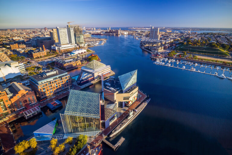
Go a short distance north and the Inner Harbor will be on the right. Baltimore was founded by the water almost 300 years ago. Once a rundown historic seaport, Inner Harbor underwent a major transformation in the mid-20th century. Though touristy, it’s energetic and colorful with numerous hotels, restaurants and attractions, including the National Aquarium and Port Discovery Children’s Museum. And, Top of the World Observation Level has spectacular views of the harbor and city. Baltimore National Heritage Area Tours & Trails offers various expert-led and self-guided walks of Inner Harbor and other neighborhoods.
Though a few blocks west of Charles Street, it’s worth mentioning the Babe Ruth Birthplace & Museum. The baseball great was raised and learned to play the game in Baltimore.
Back on Charles Street and moving north through the city’s gleaming central core, it’s about a mile to the oldest cathedral in the U.S., the Basilica of the National Shrine of the Assumption of the Blessed Virgin Mary. Or simply, the Baltimore Basilica, completed in 1821.
A couple of blocks north is the Walters Art Museum. Admission is free, so it’s always worth checking out the rotating exhibits and permanent collection spanning 5,000 years.
Dead ahead on Charles Street is the 179-foot-tall Washington Monument, honoring the nation’s first president and completed in 1829. It costs a few bucks to climb the 227 steps to the balcony for another outstanding overview of the city, complimenting the panorama from Top of the World Observation Level. During the monument’s 2014 restoration, a secret time capsule was uncovered. A copy of the Declaration of Independence, vintage coins and old newspapers were found and are now displayed at the nearby Maryland Center for History and Culture.
A quick walk from Maryland Center leads to the Eubie Blake National Jazz Institute and Cultural Center. A native Baltimorean, Blake was a pianist and composer of ragtime and vaudeville tunes. The institute celebrates the musician and other jazz greats such as Cab Calloway, Billie Holiday and Chick Webb.
Again on Charles Street, the eclectic Station North Arts and Entertainment District features galleries, studios, restaurants, bars, breweries and music venues. Farther north, the Lovely Lane Museum and Archives houses United Methodist artifacts, a manuscript collection and a research library.
Soon Charles passes by Johns Hopkins University where you’ll find the Baltimore Museum of Art, highlighted by the 33 works in the Sculpture Gardens. Also on campus, the Homewood Museum is a National Historic Landmark and one of America’s best examples of Federal-period architecture. Homewood’s exhibits focus on life in early 19th-century Baltimore. The Historic Charles Street byway continues another six miles before ending at ending at I-695.
Harriet Tubman Underground Railroad Byway – All-American Road – 125 miles
Maryland began as a colony in 1634 and for the next 230 years, slaves labored in every industry, providing the foundation for the state’s economy. The Underground Railroad was a network of routes and safe havens that helped enslaved people flee the fifteen slave states. Maryland native Harriet Tubman is synonymous with the Underground Railroad. In 1849, she escaped to Pennsylvania, traveling alone and generally at night. Over the next 10 years or so, she made some 13 secret trips to Maryland rescuing about 70 family and friends.
This byway traces some of the routes that Tubman and others followed from Maryland into Delaware and onto Pennsylvania. Most of the 46 sites are in Maryland. Read our Delaware article for the locations in that state.
The byway begins in Cambridge, on Maryland’s Eastern Shore, about 60 miles southeast of Annapolis and 90 miles southeast of Baltimore. Here are our favorite stops but to see the complete list, visit the byway’s official website.
Cambridge is a small city on the Choptank near where the river flows into Chesapeake Bay. The Chesapeake Country byway passes through here, too. Take a look at our article above. Cambridge’s historic downtown features several Underground Railroad byway sites and a logical starting point is the Harriet Tubman Museum and Educational Center. Tubman was born a few miles from Cambridge and the museum features displays about her life, slavery, the Underground Railroad and Civil War. There’s also an amazing mural.
A few blocks away, Long Wharf extends into the Choptank River and along this waterfront, kidnapped Africans were sold. In the 1700s, Cambridge was a regional center for the slave trade, where ships arrived from Africa and the West Indies. Later, thousands of slaves were shipped from this wharf to plantations in the Deep South.
From Long Wharf, it’s three miles to the Stanley Institute, a one room school that was moved to this location in 1867, after the Civil War ended. Used until the 1960s, the Rock School was built and run by African Americans and “stands as a testament to the black community’s determination to educate their children in a segregated school system.”
Ten minutes west is Malone’s Methodist Episcopal Church, founded in 1864 as the area’s first African American church. Harriet Tubman was born around 1822 on a nearby farm. It’s also believed she worked and lived in the area with her free husband, John. For years, footpaths through the woods connected nearby communities, creating a social network for free and enslaved blacks.
Heading three miles west on Maryland State Highway 16, look for Joseph Stewart’s Canal on the right as you cross Parsons Creek. The seven-mile canal was dug by enslaved and free blacks and used to float logs and agricultural products to nearby wharves. A secret network of communication also developed, which Harriet Tubman learned while working the forests and docks.
After escaping to Pennsylvania, Tubman used the network to message her three brothers through Jacob Jackson, a free black veterinarian. Once she learned her brothers were soon to be sold, Tubman got word to Jackson that she would rescue them. Jackson’s home site is part of the Harriet Tubman Underground Railroad National Historical Park, which you can reach by returning east toward Cambridge on MD 16. Go seven miles then turn right onto MD 335. It’s four miles to the park’s visitor center, featuring in-depth exhibits on the Underground Railroad and Tubman’s heroic life.
The park is adjacent to Blackwater National Wildlife Refuge which hasn’t changed much since Tubman’s time. Well, except for the ghost forests, trees killed by rising sea levels due to climate change. Several escapes happened here, although Tubman isn’t known to have been involved. Today, birdwatching, hiking, paddling and deer hunting are popular. It’s the same setting and tidal marsh conditions Tubman and others would have mastered while navigating, trapping and foraging for food and hiding from pursuers.
Another 5.5 miles east and you’ll see Harriet Tubman’s Childhood Home. It’s just a sign; the original house is gone. Go a mile more to Bucktown General Store, site of Tubman’s “First Act of Defiance.” While shopping, she was ordered to help restrain another slave. Tubman resisted, the man bolted and the overseer threw a two-pound weight which hit Tubman, nearly killing her and causing a severe lifelong injury.
Now, the byway heads north and in about 23 miles, you’ll reach the home of white Quaker abolitionists, Jacob and Hannah Leverton. It’s privately owned so you can only look, but the site is considered the region’s main stopping place for the Underground Railroad. Train terms were used, and so guides, like Tubman, were called conductors. The Levertons were agents and their residence, a station house. Throughout Maryland and Delaware, Quakers, people of other faiths and free blacks helped hide and lead freedom seekers as they pushed northward to Pennsylvania.
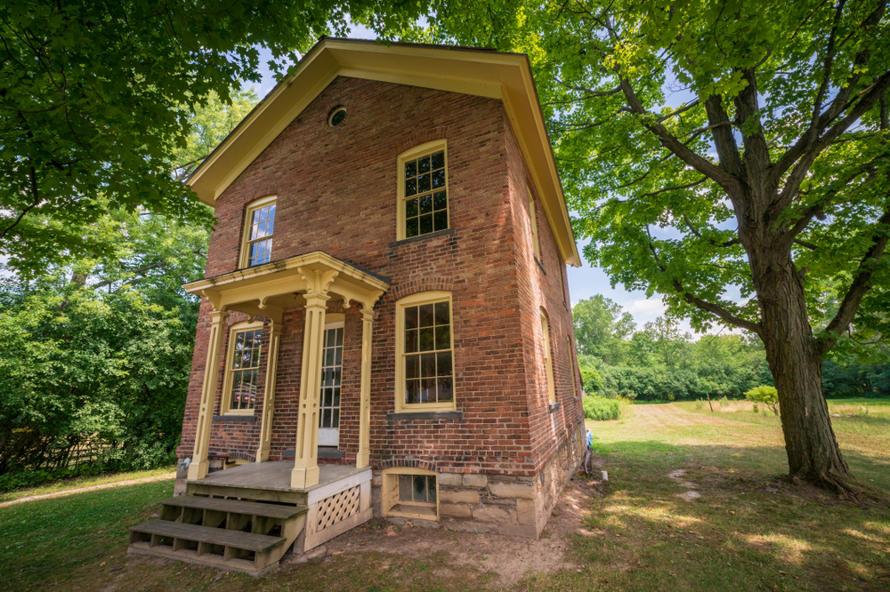
From the Leverton Home, it’s five minutes to the Linchester Flouring Mill Complex where free and enslaved blacks worked together. The water-powered mill stopped running in 1979 but you can tour by appointment. Go another five miles north to the James Webb Cabin. Built in the 1850s by a free African American farmer, it’s a rare survivor of housing typical for black and many poor white families.
Continuing 10 minutes north, the William Still Interpretive Center is an 1820s one room house with a “slave cabin” interior and a garden. The center tells the story of the Still family’s struggle for freedom through escape and resettlement. William Still became a prominent figure of the Underground Railroad. He was Chairman of the Philadelphia Vigilance Committee of the Pennsylvania Anti-Slavery Society, helping some 1,500 freedom seekers escape.
Denton is another 10 minutes north and as you drive through town, look for the Caroline County Courthouse. It was rebuilt after the Civil War, but the location was the site of a slave market and jail. Five minutes west across the Choptank River is the Tuckahoe Neck Meeting House, one of five Quaker meeting houses in the county whose members ran a local Underground Railroad network.
From Denton, continue north on MD 313 to Greensboro and Red Bridges Road where the Harriet Tubman Underground Railroad Byway story continues in our Delaware article.
Religious Freedom Byway – National Scenic Byway – 140 miles

In 1634, Roman Catholic settlers from England arrived at a large peninsula jutting into Chesapeake Bay. They founded the Maryland colony where various faiths could live in peace. At the same time, Native Americans were displaced and slavery began, lasting 230 years. This byway follows rural roads past numerous age-old churches and historic sites as it winds through the tidal wetlands of southern Maryland.
From The White House and downtown Washington, it’s 34 miles south to Smallwood State Park. Located on the banks of the Potomac River, the park has nature trails, a picnic area, marina, boat launch and a campground. You can also tour Smallwood’s Retreat. Built in 1760, it’s the restored home of General William Smallwood, the highest ranked Marylander who served in the American Revolutionary War.
Continue 6.5 miles south on Maryland State Highway 425 to Durham Parish Church. Surrounded by gravestones, the present church dates to 1732. General Smallwood attended services in the original building. Go 2.5 miles farther to Friendship Farm Park for more hiking, fishing and other outdoor activities.
From the park, it’s 12 miles north to Port Tobacco, founded in 1634. The reconstructed courthouse has exhibits on tobacco and the Civil War. The town is also where John Wilkes Booth met with co-conspirators to plot President Abraham Lincoln’s assassination. Port Tobacco resident George Atzerodt was later convicted and hanged for his role.
Next, head two miles north to the Thomas Stone National Historic Site. You can tour the 1770s Georgian mansion with a tobacco barn, corn crib and family cemetery. Named Haberdeventure, the estate was owned by Thomas Stone, a Maryland signer of the Declaration of Independence.
It’s 5.5 more miles to the Mount Caramel Monastery, America’s first Catholic convent for women. Founded in 1790, today the nuns still work and pray inside a gated community, but the chapel and gift shop are open for visitors. The Carmelite Nuns were brought to America by a former pastor at St. Ignatius, one of the oldest continuously active Catholic Parishes in the U.S. To see the church, go 7.5 miles south, passing through Port Tobacco again. St. Ignatius has a photo-worthy cemetery and great river views from a bluff. The church lies inside the undeveloped Chapel Point State Park, good for fishing, kayaking and canoeing.
From St. Ignatius, it’s 20 minutes east on US 301 and MD 234 to Chaptico and another really old church, Christ Episcopal. While the congregation dates from 1640, the church itself was finished in 1736 and then heavily damaged by British troops during the War of 1812. With an arched ceiling, curved windows and ornate columns, this church’s interior is particularly pretty.
Driving south down another peninsula to the edge of the Potomac River, it’s 13 miles to Coltons Point and one of the byway’s most significant stops. With exhibits and a one-room schoolhouse, St. Clement’s Island Museum gives the history of English colonization. Just across the water is St. Clement’s Island where the first settlers landed in 1634. You can only reach the island by boat and daily water taxi service from the museum runs late March through October.
From Coltons Point, it’s 15 miles to Newtowne and St. Francis Xavier Church, the oldest Catholic church in the original 13 colonies. Then, go six miles to Leonardtown where you can check out the Old Jail Museum, built in 1876. Nearby, Tudor Hall is a genealogical and historical research center located in a colonial house that’s more than 250 years old. Leonardtown is fun to walk, exploring the town square, restaurants and shops.
From Leonardtown, drive another 10 miles to Valley Lee and St. George’s, the oldest Episcopal parish in Maryland where services have been held continuously since 1638. The current church was built in 1799 and is a stop on the way to Piney Point. In addition to beaches, kayaking and seafood, Piney Point has a maritime history museum and a lighthouse, the oldest on the Potomac, built in 1836.
From Piney Point, head inland again and go 16 miles to Historic St. Mary’s City, a living history museum with a recreated Woodland Indian hamlet, tobacco farm with animals, a working printing press and reconstructed tall ship.The byway dead ends at Point Lookout State Park, where the Potomac River meets Chesapeake Bay. Once a Union outpost during the Civil War, more than 52,000 Confederate soldiers were imprisoned here. There’s a lighthouse plus camping, picnicking, swimming, fishing, birding and hunting.
